Location of Dokdo
What kind of island is Dokdo. and where is it located?
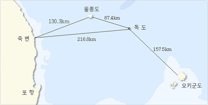
Most Koreans are probably aware that Dokdo is the easternmost territory of Korea, and that it is a neighboring island to Ulleungdo in the East Sea.
To be more precise, Dokdo is an island of Korea located 87.4 kilometers from Ulleungdo, and 216.8km from Jukbyeon Port in Uljin, Gyeongsangbuk-do.
In comparison, for Japan. the closest island is Okinoshima, which is 157.5 kilometers away—almost twice the distance between Dokdo and Ulleungdo.
Meaning of Dokdo
Dokdo is an island that belongs to Ulleung-gun in Gyeongsangbuk-do, Korea. It is home to a total of 2,046 species of wildlife, including 19 endangered animal species, 123 types of plants, 387 types of seaweed, 40 types of microalgae, 64 types of microorganisms. 193 types of insects, 5 types of mammals, 193 types of birds, 806 types of invertebrates, 180 types of fish, and 55 types of protozoa. Dokdo is an island of unique value.
For this reason, Dokdo was designated in 1982 as Natural Monument NO.336, the “Dokdo Island Natural Reserve”, and the entire island is protected and managed under the Cultural Heritage Protection Act.
In geological terms, Dokdo is the oldest volcanic island in Korea. It was formed between about 4.6 million and 2.5 million years ago when lava erupted and solidified 2,000 meters under the sea. Ulleungdo is estimated to have formed between about 2.5 million and 10,000 years ago, and Jeju Island, the youngest, between 1.2 million and 10,000 years ago.
Like Ulleungdo and Jeju Island, Dokdo has many traces of volcanic activity. In 2012, the Korean government designated four sites on Dokdo—Cheonjang-gul Cave, Samhyeongjegul-bawi Cave Rock (Three Brothers Cave Rock), Dongnimmun-bawi Rock (Independence Gate Rock), Sutdol-bawi Rock (Whetstone Rock)— as National Geoparks of Korea to preserve the outstanding geological heritage of Dokdo.
300,000
visitors per year
123
types of plants
180
species of fish
193
species of birds


Natural Monument
National Geopark
Easternmost island
Dokdo Island
Natural Reserve
Designated in 1982
Ulleungdo-Dokdo
National Geopark
Designated in 2012
The easternmost island of
the Korean Peninsula
The center of maritime territory
in the East Sea
Figures of Dokdo
The General of Silla Dynasty, The Sovereign of Gangneung Area
Isabu
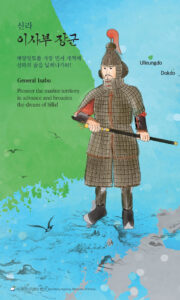
In 512, General Isabu of Silla incorporated the maritime nation of Usan-guk, which included Ulleungdo and its nearby islands like Dokdo, into Silla territory.
In other words, since the year 512, Ulleungdo and Dokdo, the islands in the East Sea, have been part of Korean history.
On Dongdo (East Island), there is a road named “Dokdo Isabu-gil”, and about 42 kilometers southeast of Dokdo, about 136 meters under the sea, there is an underwater mountain called “Isabu Seamount”.
Fisherman and Civilian Diplomat of Joseon Dynasty
Ahn Yong-bok
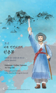
Ahn Yong-bok, a fisherman from the Joseon dynasty, traveled to Japan in 1693 and 1696. During those visits, he clearly informed local and central government officials in Japan that Ulleungdo and Dokdo are Joseon territory.
Thanks to his actions, the Edo Shogunate, which was the central government of Japan at the time, canceled the sea passage permits it had previously issued for the Ulleungdo area and issued an order banning Japanese people from crossing over to Ulleungdo and Dokdo.
On Seodo (West Island), there is a road named “Dokdo Anyongbok-gil”, and about 40 kilometers east of Ulleungdo, about 457 meters under the sea, there is an underwater mountain called “Ahn Yong-bok Seamount”.
The County Magistrate of Uldo-gun who oversaw Ulleungdo and Dokdo
Sim Heung-taek
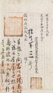
Sim Heung-taek served as the county magistrate of Uldo-gun from January 26, 1903, to March 13, 1907, during the Korean Empire (Daehan Jeguk) period.
On March 28, 1906, after hearing from Japanese visitors that Japan had unilaterally incorporated Dokdo into Shimane Prefecture in 1905, Sim immediately wrote a report about Japan’s wrongdoing the following day, March 29, and submitted it through Gangwon-do to the State Council (Uijeongbu).
In the aforementioned report, Sim wrote “Dokdo, which is under the jurisdiction of this country (本郡所屬獨島)”, confirming that Dokdo continued to be part of Uldo-gun, as stated in Imperial Decree No. 41 of the Korean Empire on October 25, 1900, and reaffirming the territorial sovereignty of Korea over Dokdo.
Starting in 1907, Sim served as the county magistrate of Hoengseong in Gangwon-do. However, he was dismissed in 1911 for resisting Japan after it took away Korea’s sovereignty in 1910.
It is known that he later devoted himself to Korea’s independence by raising military funds and supporting independence movements until the end of his life.
About 15 kilometers east of Dokdo, about 146 meters under the sea, there is an underwater mountain called “Sim Heung-taek Seamount”.
The Name of Dokdo
Historically, Dokdo has been called by many different names in Korea and other countries.
Some of these names were used by the government, while others were given by local residents or visitors based on the appearance or features of Dokdo.
In the West, the island was sometimes named after the ships used by people who discovered it.
In the past, many countries used a variety of incorrect names for Dokdo. However, both in the present and in the future, the name of the island is Dokdo.
That is because Korea, which has territorial sovereignty over Dokdo. officially uses the name Dokdo in its legal, administrative and geographical information.
Today, the name Dokdo is used by the Korean government, the people living on and around the island, and all Korean citizens who recognize Korea’s sovereignty over the island.
If you find any incorrect names or information about Dokdo—or anything else related to Korea—being used overseas, let us know!
Let us all become Ahn Yong-bok of the 21st century and take action to correct false names and help spread the correct name, Dokdo, around the world.
* Correcting Errors about Korea “21C Yi Sun-sin Error Correction Project”: http://korea.prkorea.com
* National Policy Suggestion Platform “Woollim”: https://www.woollimkorea.net
* National Policy Communication Platform “Yeollim”: https://www.yeollimkorea.net
* Report Errors about Korea “Facts Korea”: https://www.factsaboutkorea.go.kr/report/mrequest121.do?ln=en
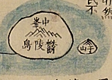
Usando (于山島)
In Samguk Sagi (History of the Three Kingdoms), compiled in 1145, it is written that Silla took ownership of Usan-guk in 512. In Sejong Sillok Jiriji (Geographical Records in the Annals of King Sejong), compiled in 1454, it is written that “the two islands of Usan [Dokdo] and Mureung [Ulleungdo] are not located far apart from each other so Dokdo is visible from Ulleungdo on a clear day”.
In Dongguk Munheon Bigo (Reference Compilation of Documents on Korea), compiled in 1770, it is written that “Ulleung and Usan are both territories of Usan-guk … Usan is what the Japanese refer to as Matsushima [name for Dokdo used by Japan]”. It can be confirmed that Usando is present-day Dokdo and was part of the territory Usan-guk.
There have been cases where the character U (于) in Usando was written incorrectly, leading to the island being called Jasando (子山島) or Cheonsando (千山島).
Haejwa Jeondo (created in the late 18th century)
*source: National Museum of Korea
Gajido (可支島)
In Jeongjo Sillok (Annals of King Jeongjo), compiled in 1805, there is a record that in 1794, a territorial protection official by the name of Han Chang-guk departed from Uljin on April 21, arrived at Ulleungdo the day after (April 22) and patrolled until April 25, then went to Gajido on April 26 and caught two sea lions.
At the time, many sea lions, called “Gaje” or “Gangchi”, lived on Dokdo, so the island was also called Gajido—a name that used Chinese characters to represent “Gaje”.
Even today, on the northwestern side of Dokdo, there are large flat rocks called Keungaje-bawi Rock (Big Sea Lion Rock) and Jageungaje-bawi Rock (Little Sea Lion Rock), where many sea lions used to live.
Seokdo (石島)
On October 25, 1900, the Korean Empire (Daehan Jeguk) ordered Imperial Decree No. 41, that “Seokdo (Dokdo) shall be placed under the jurisdiction of Uldo-gun (Uldo County)”.
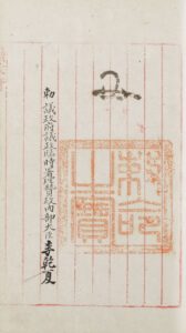
Imperial Decree No. 41
*source: Kyujanggak Institute for Korean Studies, Seoul National University
At the time, Ulleungdo residents called Dokdo “Dolseom” or “Dokseom” based on its appearance.
In the Korean Language Dictionary (朝鮮語辭典) published by the Korean Language Dictionary Compilation Committee on July 10, 1938, the Korean word “dok (독)” is recorded as a dialect word for “dol (돌, stone)”. This confirms that “Dokdo” in Hangeul (독도) and “Seokdo” in Chinese characters (石島) follow the same word principle.
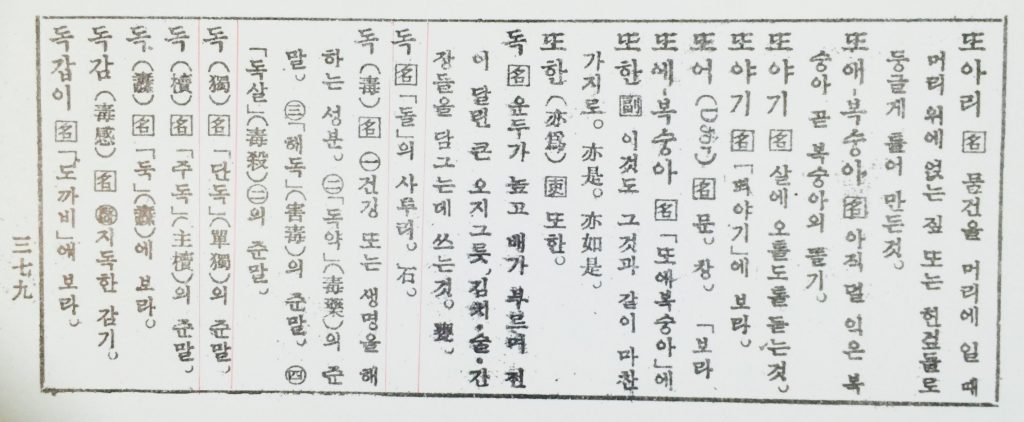
cover of the Korean Language Dictionary (1938) and the section under “Dok”
*source: National Library of Korea
In Joseon Jiji Jaryo (朝鮮地誌資料), a geographic reference compiled in 1914 by the Japanese Government-General of Korea, based on surveys of Korea’s geographical information conducted in 1911, there are other examples where place names using the Chinese character for stone (石), like Seoksan (石山) and Seokgol (石谷), were written in Korean as Doksan and Dokgol, just like Dokdo (石島).
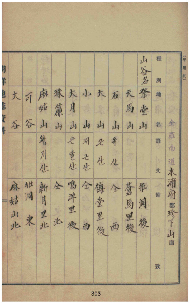
Examples of place names where the Chinese character ‘石’ (meaning “stone”) is
written as ‘독’ in Korean, such as 石山 (Doksan), 石谷 (Dokgol), and 石島 (Dokdo).
Quoted from Joseon Jiji Jaryo, Jeollanam-do Volume 3-1 (Volume 6), Mokpojugun (木浦廚郡)
*source: National Library of Korea
On June 13, 1948, it was reported in the newspaper article that the name “Dokdo” originated from “Dolseom (stone island, 石島)”.
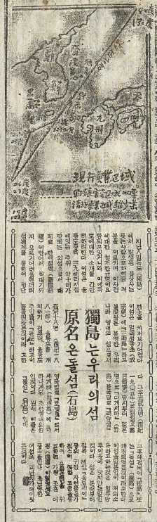
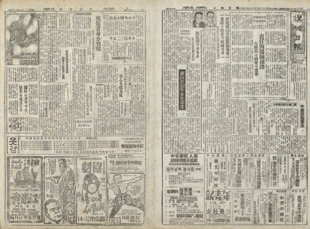
Hanseong Ilbo “Dokdo is our island, original name is Dolseom”
*source: Korea Newspaper Archive, National Library of Korea
✔ Dokdo (獨島)
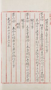
In 1906, Sim Heung-taek, the county magistrate of Uldo-gun, learned from Japanese visitors to Ulleungdo that Japan had illegally incorporated Dokdo into its territory in 1905. The next day, he wrote a report and sent it to the Uijeongbu (State Council) through the governor (gwanchalsa) of Gangwon-do. In the report, he wrote “Dokdo, which is under the jurisdiction of this country”, showing that the name “Dokdo” was used at the time. This also confirms that Dokdo continued to be part of Uldo-gun, as stated in Imperial Decree No. 41 (1900), and reaffirms Korea’s territorial sovereigny over Dokdo.
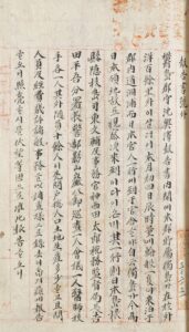
The report by Shim Heung-taek, delivered through Acting Governor Yi Myeong-rae,
and the directive from the Vice Prime Minister of the Uijeongbu in response
*source: Kyujanggak Institute for Korean Studies, Seoul National University
The name “Dokdo” is the official name widely used in all areas of the Korean government, including legal, administrative and geographical information, as well as by the international community.
Incorrect Names of Dokdo
used around the world
Please help make sure Dokdo is called by its correct name!
Liancourt
In 1849, people on the French whaling ship Le Liancourt discovered Dokdo and named the island after the ship. In 1857, the French Navy also referred to the island as Rochers Liancourt.
Unfortunately, the name Liancourt began to spread widely in the West since then, and even today, there are many cases overseas where the name is used.
Menelai (Менелай), Olivutsa (Опивуца)
In 1854, people on the Russian ship Olivutsa (Опивуца), part of the navy frigate Pallada (Фрегат Паллада), discovered Dokdo and drew an illustration of the island. Based on this information, the Russian Navy’s Hydrographic Service published a map of Korea titled East Coast of Korea (Восточный берег полуострова Кореи).
East Coast of Korea (1857)
*source: Northeast Asian History Foundation
In this map, Dokdo was divided into its two main islets—Dongdo (East Island) and Seodo (West Island)—for the first time in the West. Dongdo was labeled Menelai (Менелай) and Seodo was labeled Olivutsa (Опивуца).
Hornet
In 1855, people on the British corvette Hornet discovered Dokdo and named it Hornet Island after the ship.
Matsushima (松島 or 松嶋)
In Records on Observations in Oki Province (隱州視聽合記, Inshu Shicho Gakki), one of the earliest Japanese texts published in 1667, Dokdo is written as Matsushima (松嶋). It is a record left by a Japanese official by the name of Saito Hosen (齋藤豊仙), who saw Dokdo and Ulleungdo while drifting at sea. It is written, “Inshu [Oki Islands] shall mark Japan’s northwesternmost boundary”.
*reference: Ulleung Grand Culture Encyclopedia
After that, in other Japanese maps and documents including Tottori-han’s Submission (鳥取藩答弁書, 1695), Memorandum on the Arrival of a Vessel from Joseon in 1696 (元祿九丙子年 朝鮮舟着岸 一卷之覺書, 1696), Revised Complete Map of Japanese Lands and Roads (改正日本與地路程全圖, 1779), Confidential Inquiry into the Particulars of Relations with Joseon (朝鮮國交際始末內探書, 1870), Dajokan Order (太政官 指令, 1877), Simplified Map of Isotakeshima (磯竹島略図, 1877), Dokdo was recorded as Matsushima (松島 or 松嶋) and Ulleungdo was recorded as Takeshima (竹島 or 竹嶋).
Yanko Island (ヤンコ島), Liancourt Rocks (リアンクルド岩)
In the late 19th century, influenced by Western maps that labeled Dokdo as Liancourt, Japan also referred to Dokdo as Yanko Island (ヤンコ島) or Liancourt Rocks (リアンクルド岩).
In 1903, in the Guidlines for Fisheries in the Korean Sea (韓海通漁指針) by the Black Dragon Society (黒龍会), a right-wing organization of Japanese imperialism, it recognizes Liancourt Rocks (Dokdo) as part of Ulleungdo.
In 1904, in the Daily Operation Records of the Niitaka (軍艦新高行動日誌), Imperial Japanese Navy Warship Cruiser, it was recorded as follows: “Information provided by people who saw Liancourt Rocks (Dokdo) from Matsushima (Ulleungdo) … Liancourt Rocks are written as Dokdo by Koreans, whereas they are called Liancourt Rocks by Japanese fishermen”.
Takeshima (竹島)
Japan had originally called Dokdo Matsushima (松島 or 松嶋) and Ulleungdo Takeshima (竹島 or 竹嶋). However, in the late 19th century, under the influence of Western maps, confusion arose regarding the information and names of Dokdo and Ulleungdo. As a result, Japan reversed the names—referring to Dokdo as Takeshima (竹島) and Ulleungdo as Matsushima (松島).
In 1905, during the Russo-Japanese War, Japan attempted to secretly and illegally incorporate Dokdo—Korean territory both then and now—for military purposes in order to monitor the Russian fleet, and bean calling it Takeshima (竹島).