Historically, Dokdo has been recognized and managed as Korean territory ever since Usan-guk was incorporated into the Silla Kingdom in the year 512. This is supported not only by Korean records but also by documents from Japan and the international community.
On the other hand, Japan claims—without basis—that it established sovereignty over Dokdo in the 17th century. However, before Japan’s secret and illegal attempt to incorporate Dokdo at the time, Japan had never once officially claimed Dokdo as its own.
There are many historical records about Dokdo from Korea, Japan and Western countries. Here are some of the key events that are organized by time period.
1145 Samguk Sagi (三國史記, History of the Three Kingdoms)
In 1145, the 23rd year of King Injong’s reign during the Goryeo Dynasty, Kim Bu-sik compiled the Samguk Sagi under royal order. This is the oldest surviving historical record in Korea.
Through Samguk Sagi, we learn that in the year 512, the maritime state of Usan-guk—made up of Ullengdo and Dokdo—was incorporated into the territory of the Silla Kingdom.
[translation]
In the thirteenth year, in June of summer, Usan-guk submitted, and from then on, offered local products as tribute each year.
[original text]
十三年, 夏六月, 于山國歸服, 歲以土宜爲貢。
Samguk Sagi, Volume 4, Annals of Silla, Part 4: In the 13th year of King Jijeung’s reign (512), in June, General Isabu conquered Usan-guk.
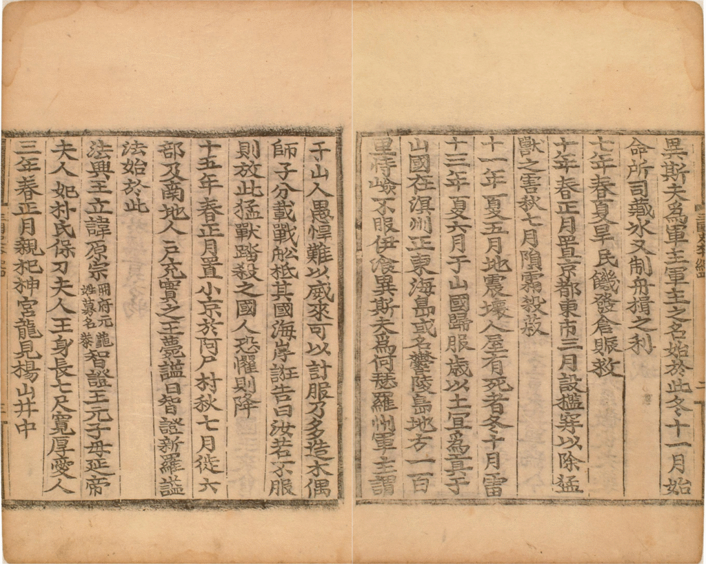
*source:
History.net, National Institute of Korean History
Database of Korean History, National Institute of Korean History
1145 Sejong Sillok Jiriji (世宗實錄 地理志, Geographical Records in the Annals of King Sejong)
In Joseon Wangjo Sillok (Annals of the Joseon Dynasty), the official historical record of the Joseon government, there is Sejong Sillok Jiriji, which was compiled in 1454 (the 3rd year of King Danjong’s reign). In it, it is recorded that Dokdo and Ulleungdo were islands belonging to Uljin-hyeon (Uljin prefecture), Gangwon-do. It is also written that these islands were part of Usan-guk during the Silla Dynasty, and that Dokdo and Ulleungdo are not far from each other—one can see Dokdo from Ulleungdo on a clear day.
[translation]
The two islands of Usan [Dokdo] and Mureung [Ulleungdo] are located in the middle of the sea due east of the hyeon [Uljin county].
The two islands are not far apart from each other and are visible on a clear day. They were called Usan-guk or Ulleungdo during the Silla period.
[original text]
于山武陵二島 在縣正東海中。
二島相距不遠 風日淸明 則可望見。
新羅時, 稱于山國, 一云鬱陵島。
Sejong Sillok, Volume 153, Jiriji – Uljin-hyeon, Samcheok Protectorate, Gangwon-do.
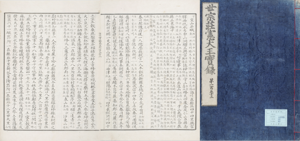
*source: The Veritable Records of the Joseon Dynasty, National Institute of Korean History
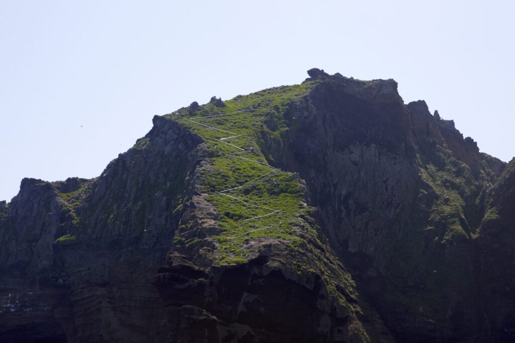
Just like it says in Sejong Sillok Jiriji, we can still see today that on clear days, Ulleungdo and Dokdo are close enough to be seen from each other.
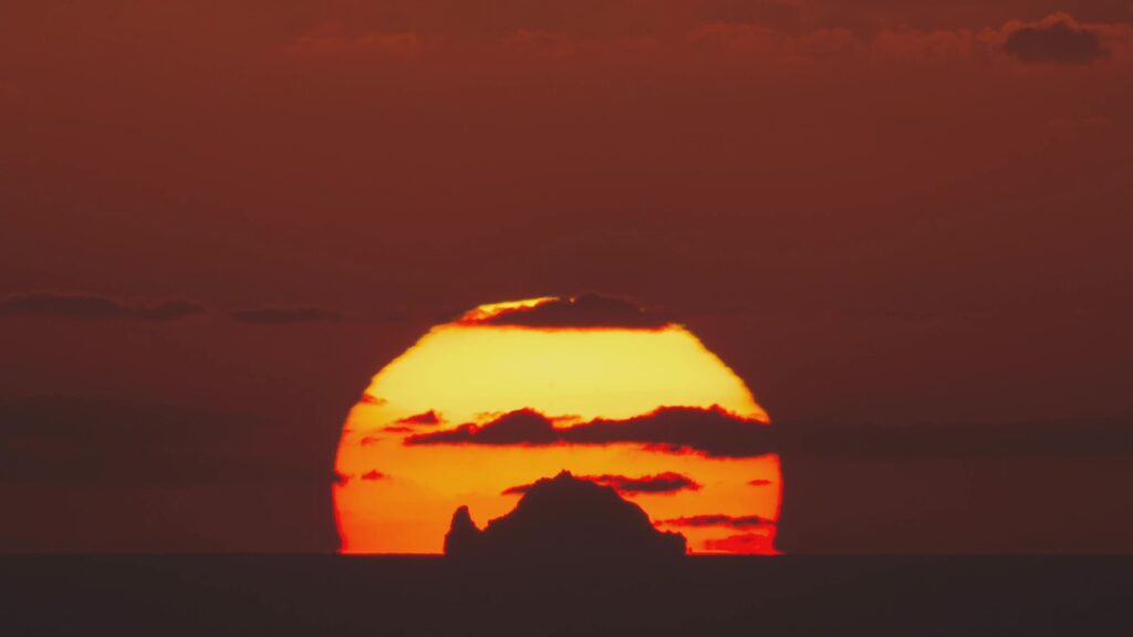
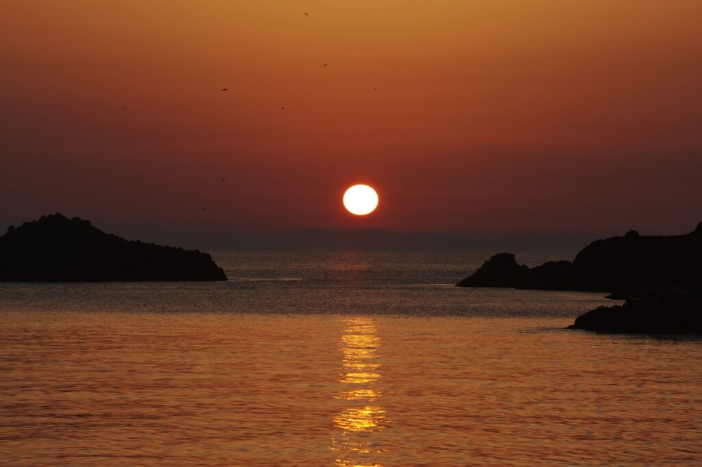
(left) Dokdo seen from Ulleungdo
*source: Ministry of Foreign Affairs, Republic of Korea YouTube ‘Dokdo sunset from Ulleungdo’
(shot by Kwon O-chul)
(right) Ulleungdo seen from Dokdo
*source: Ministry of Foreign Affairs, Republic of Korea YouTube
1660 Records of the Oya Family (大谷家文書)
In the 1600s, fishermen from the Oya (大谷) and Murakawa (村川) families in Tottori-han (鳥取藩), Japan, secretly received permission from the Edo Shogunate to fish around Ulleungdo and Dokdo without the knowledge of the Joseon government. The Oya family even left behind a document stating that Dokdo is a part of Ulleungdo.
In 1693, these families abducted a Joseon man named Ahn Yong-bok from Ulleungdo and took him to Japan. After Ahn negotiated with the Edo Shogunate, the Japanese government issued an order banning Japanese travel to Ulleungdo and Dokdo, effectively putting an end to all Japanese fishing activities there.
[translation]
Matsushima (Dokdo) within the confines of Takeshima (Ulleungdo)
[original text]
竹嶋之內松嶋
Records of the Oya Family (大谷家文書)
* At the time, Japan called Dokdo Matsushima (Songdo / 松嶋 or 松島) and Ulleungdo Takeshima (Jukdo/ 竹嶋 or 竹島).
1667 Records on Observations in Oki Province (隱洲視聽合記)
One of the oldest Japanese documents that mentions Dokdo is the Records on Observations in Oki Province (隱洲視聽合記). It was written by Saito Hosen (齋藤豊仙), an official from the Izumo region (出雲, now the eastern part of Shimane Prefecture). He recorded what he saw after drifting across the East Sea, including sightings of Dokdo and Ulleungdo. In the record, he marked the northwestern boundary of Japan as Oki Islands in the present day.
[translation]
The two islands [Ulleungdo and Dokdo], which are uninhabited, are located towards Goryeo [Korea] in the same way that Unshu [eastern part of today’s Shimane Prefecture] is located towards Inshu [Oki Islands].
Therefore, Inshu [Oki Islands] shall mark Japan’s northwesternmost boundary.
[original text]
此二島 無人之地 見高麗 如自雲州望隱州 然則日本之乾地
以此州爲限矣
Records on Observations in Oki Province (隱洲視聽合記)
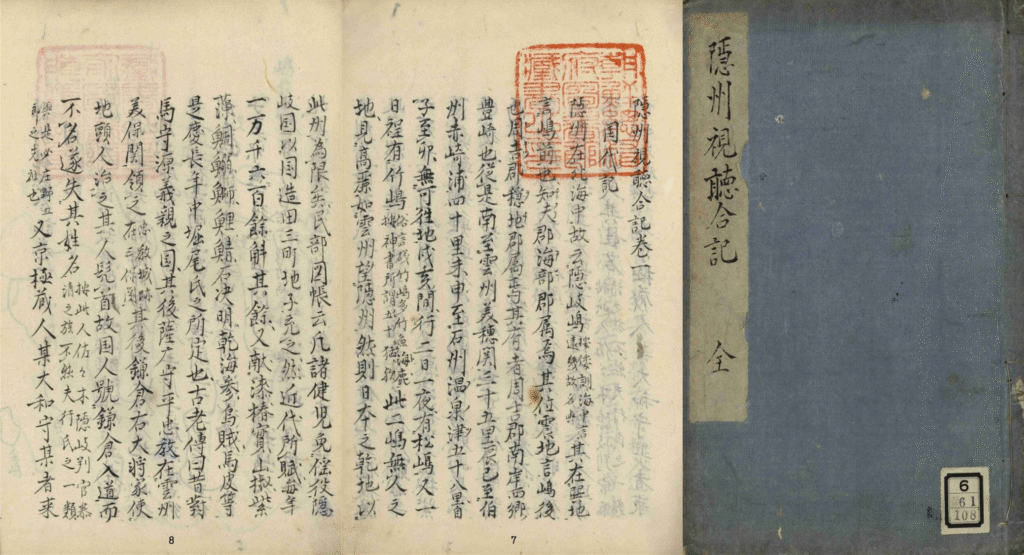
which includes a description of Japan’s northwestern boundary (Oki Island)
*source: Records of Observations in Oki Province, National Library of Korea
1693 Abduction of Ahn Yong-bok by Japanese fishermen
In the 1600s, the Oya and Murakawa families from Tottori-han in Japan were secretly fishing around Ulleungdo and its nearby island, Dokdo, based on a sea passage permit that was arbitraily issued by the Edo Shogunate. In the spring of 1693, a boatman from the Oya family encountered a group of Joseon men, including Ahn Yong-bok and Park Eo-dun, while fishing near Ulleungdo. He abducted them and took them to Tottori-han in Japan.
[translation]
Communicated with Japan regarding the issue of Ulleungdo.
[original text]
울릉도 문제를 왜와 교신하다
Sukjong Sillok, Volume 27, August 14th, the 20th year of King Sukjong’s reign (1694)
December 24, 1695 Edo Shogunate’s Inquiry regarding belonging of Dokdo
During negotiations with the Joseon government over Ulleungdo, the Edo Shogunate of Japan believed Ulleungdo belonged to Tottori-han. So, on December 24, 1695, the Edo Shogunate sent an inquiry to Tottori-han asking when Ulleungdo became a part of it and whether there were any other islands that belonged to Tottori-han.
[translation]
1. Since when has Takeshima [Ulleungdo], which belongs to Inshu and Hakushu [Inaba and Hoki: today’s Tottori prefecture], been under the jurisdiction of the two states [Inaba and Hoki]?
1. Apart from Takeshima [Ulleungdo], are there any islands that belong to the two states [Inaba and Hoki]?
[original text]
一. 因州伯州江付候竹島は、いつの頃より兩国江附属候哉
一. 竹島の外両国江附属の島有之候哉
Edo Shogunate’s Inquiry regarding belonging of Dokdo
* At the time, Japan called Ulleungdo Takeshima (Jukdo / 竹嶋 or 竹島).
December 25, 1695 Tottori-han’s Submission (鳥取藩答弁書)
In response to the Edo Shogunate’s inquiry, Tottori-han replied the next day, on December 25, 1695, that Ulleungdo, Dokdo, and any other islands did not belong to Tottori-han.
[translation]
1. Takeshima [Ulleungdo] is not an island that belongs to Inaba and Hoki [today’s Tottori prefecture].
1. As for Takeshima [Ulleungdo] and Matsushima [Dokdo], neither belongs to the two states [Inaba and Hoki] nor are there any islands belonging to these two states.
[original text]
一. 竹島は因幡伯耆附属にては無御座候…
一. 竹島松島其外両国江附属の島無御座候事
Tottori-han’s Submission
* At the time, Japan called Dokdo Matsushima (Songdo / 松嶋 or 松島) and Ulleungdo Takeshima (Jukdo / 竹嶋 or 竹島).
January 28, 1696 Ban on Sea Passage (渡海) to Ulleungdo
Based on this information, the Edo Shogunate stopped issuing sea passage permits to Ulleungdo that had previously been granted to Japanese fishermen, and on January 28, 1696, issued a ban on sea passage to Ulleungdo.
At first, it might seem that this ban only applied to Ulleungdo. However, since Japanese fisherman had been fishing not only around Ulleungdo but also around its nearby island, Dokdo, using the same permit, it is clear that the ban also applied to Dokdo.
In fact, there had never been a separate passage permit issued specifically for Dokdo, and no new permits for Dokdo were issued after the ban.
And in 1740, the Oya family, whose livelihood had become difficult due to the ban, submitted a petition asking the Edo Shogunate to lift it, stating that “sea passage to Takeshima and Matsushima (Ulleungdo and Dokdo) had been prohibited (竹嶋松島兩嶋渡海禁制)“. However, the Edo Shogunate did not take any action in response.
This shows that Dokdo was included in the 1696 ban.
Also, between 1833 and 1836, a Japanese person named Aizuya Hachiemon (會津屋八右衛門) secretly engaged in smuggling around Ulleungdo and Dokdo without the knowledge of the Edo Shogunate. He was caught by a Japanese inspector and executed in 1836 for leaving the country without permission. In the course of the investigation, he drew a map called Jukdo Banggakdo (竹島方角圖). On this map, Japan’s territory, including Oki Island, is colored yellow, while Ulleungdo (竹嶋) and Dokdo (松嶋) are colored red like the mainland of Korea. This shows that Japan recognized Dokdo as part of Korean territory at the time.
*source: Dokdo Research Series 21, Dokdo Institute, Yeungnam University
As a result of the Hachiemon incident, the Edo Shogunate issued the Ulleungdo sea passage ban once again in 1837.
1696 Ahn Yong-bok’s Voyage to Japan
In the spring of 1696, Ahn Yong-bok and his group visited Ulleungdo and once again encountered Japanese people there.
At that time, the Japanese passage ban to Ulleungdo had not yet been known in Joseon, but Ahn Yong-bok strongly scolded the Japanese for appearing again and drove them off the island. He then followed them all the way to Dokdo.
At Dokdo, he again drove out the Japanese, pursued them further through Oki Islands and reached Tottori-han. There, he made it clear to Japanese officials that Ulleungdo and Dokdo are territories of Joseon. (At the time, Ahn Yong-bok referred to Dokdo as Jasando (子山島), and the Japanese called it Matsushima (松島, Songdo)).
Ahn Yong-bok’s actions and his statements confirmed that Ulleungdo and Dokdo belong to Joseon are well documented in both the Annals of King Sukjong (Sukjong Sillok) and a record written by a Japanese official who interrogated Ahn entitled Memorandum on the Arrival of a Vessel from Joseon in 1696 (元禄九丙子年朝鮮舟着岸一巻之覚書).
1696 Sukjong Sillok (肅宗實錄, Annals of King Sukjong)
Sukjong Sillok (Annals of King Sukjong) record that in 1696, Ahn Yong-bok clearly stated to the Japanese that Ulleungdo and Dokdo belonged to Joseon. It also states that the local lords and officials of Japan who met with Ahn acknowledged that Ulleungdo and Dokdo are Joseon territory, and that they responded by making a promise to punish any Japanese person who enters Ulleungdo or Dokdo in the future.
[translation]
“‘Matsushima is Jasando, and this too is our country’s land. How dare you live here?’ The next morning, he sailed to Jasando, where the Japanese were lined up boiling down fish oil in cauldrons. He struck the cauldrons with a stick and shouted loudly at them. The Japanese gathered their belongings, loaded them onto their boat, raised the sail, and left. He then boarded a boat and gave chase.
(omitted)
He was then told: ‘Since both islands now belong to your country, if anyone trespasses again, and the island lord unlawfully invades, report it through an official letter and send it with a designated interpreter—we will respond with strict punishment.’”
[original text]
‘松島卽子山島, 此亦我國地, 汝敢住此耶?’ 遂以翌曉, 拕舟入子山島, 倭等方列釜鬻煮魚膏。 渠以杖撞破, 大言叱之, 倭等收聚載船, 擧帆回去, 渠仍乘船追趁,
(중략)
仍謂渠曰: ‘兩島旣屬爾國之後, 或有更爲犯越者, 島主如或橫侵, 竝作國書, 定譯官入送, 則當爲重處。’
Annals of King Sukjong, Volume 30, September 25th, the 22nd year of King Sukjong’s reign (1696), second entry for the day (Muin)
Annals of King Sukjong, Volume 30, detailing his activities
*source: The Veritable Records of the Joseon Dynasty, National Institute of Korean History
Thanks to Ahn Yong-bok’s efforts in 1693 and 1696, Japan recognized Ulleungdo and its neighboring island Dokdo as Joseon territory and prohibited Japanese access to these islands. As a result, Joseon strengthened its records and government oversight of Ulleungdo, Dokdo, and the surrounding islands.
The Edo Shogunate canceled the sea passage permits (渡海免許) it had previously issued for fishing around Ulleungdo and Dokdo. From 1696 onward, it issued a ban on sea passage (渡海禁止令), forbidding Japanese people from fishing or crossing the area.
Meanwhile, the Joseon government boosted its efforts by sending officials (搜討使) and improving government records related to Ulleungdo and its nearby islands, including Dokdo.
From 1416, the 16th year of the reign of King Taejong, the Joseon government regularly checked the situation around Ulleungdo and Dokdo. They sent government-appointed officials to remove illegal residents and send them back to the mainland.
This activity slowed down during the 1600s due to the devastation caused by the Japanese invasion (Imjin Waeran) and the Manchu invasion (Byeongja Horan). However, after Ahn Yong-bok’s first landing in Japan in 1693, the inspections resumed in 1694, happening roughly every three years. Later in 1794, during the reign of King Jeongjo, the inspections became more frequent, occurring every two years.
In the late Joseon period, the inspections were mainly carried out by the military commander of the Samcheok region, called Samcheok Yeongjang (三陟營將), and the naval commander of the Uljin region, called Wolsong Manho (越松萬戶).
These inspectors usually waited for favorable winds blowing hard toward Ulleungdo from their areas of jurisdiction—Samcheok (Samcheok Port, Jangho Port) or Uljin (Jukbyeon Port, Gusan Port, Wolsongpo)—before setting out.
Today, in Giseong-myeon, Uljin-gun, Gyeongsangbuk-do, the part of a building called Daepungheon (待風軒) Hall, meaning “the house that waited for the wind”, still remains. This building was one of the preparation and departure spots for the inspection missions.
1696 Memorandum on the Arrival of a Vessel from Joseon in 1696
(元祿九丙子年 朝鮮舟着岸 一卷之覺書)
A Japanese official who interrogated Ahn Yong-bok from May 20 to 22, 1696, wrote a document on May 23, 1696. In it, the official introduced the eight provinces of Joseon and, based on Ahn Yong-bok’s testimony, the map Ahn presented, and supporting Japanese documents, recorded that Ulleungdo and Dokdo are islands that belong to Gangwon-do in Joseon.
[translation]
Takeshima (Ulleungdo) and Matsushima (Dokdo) belong to Gangwon province.
[original text]
江原道
此道ノ中ニ竹嶋·松嶋有之
Memorandum on the Arrival of a Vessel from Joseon in 1696
* At the time, Japan called Dokdo Matsushima (Songdo / 松嶋 or 松島) and Ulleungdo Takeshima (Jukdo / 竹嶋 or 竹島).
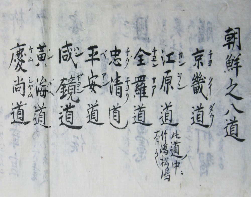
which describes the Eight Provinces of Joseon
*source: Dokdo, Ministry of Foreign Affairs, Republic of Korea
1770 Dongguk Munheon Bigo (東國文獻備考, Reference Compilation of Documents on Korea)
Dongguk Munheon Bigo is an official document of the Joseon government that was compiled by the royal order of King Yeongjo and published in 1770, the 46th year of his reign. It is a comprehensive document in which the culture, systems, institutions of Joseon are organized—much like the encyclopedia of today.
In it, it is clearly recorded that Usando (于山島) belonged to the ancient state of Usan-guk (于山國). It even includes the name Matsushima (松島), which was the name Japan used at the time for Dokdo, confirming Dokdo as part of Joseon territory.
[translation]
Ulleung and Usan (Dokdo) are part of the territory of Usan state, and Usan (Dokdo) is written as Matsushima by the Japanese people.
[original text]
于山島 鬱陵島… 二島一卽于山…
鬱陵于山皆于山國地 于山則倭所謂松島也
Dongguk Munheon Bigo, Volume 9, Geography Section 13, Border Defense 3, Maritime Defense 1 – Eastern Sea Coastal Defense
* At the time, Japan called Dokdo Matsushima (Songdo / 松嶋 or 松島) and Ulleungdo Takeshima (Jukdo / 竹嶋 or 竹島).
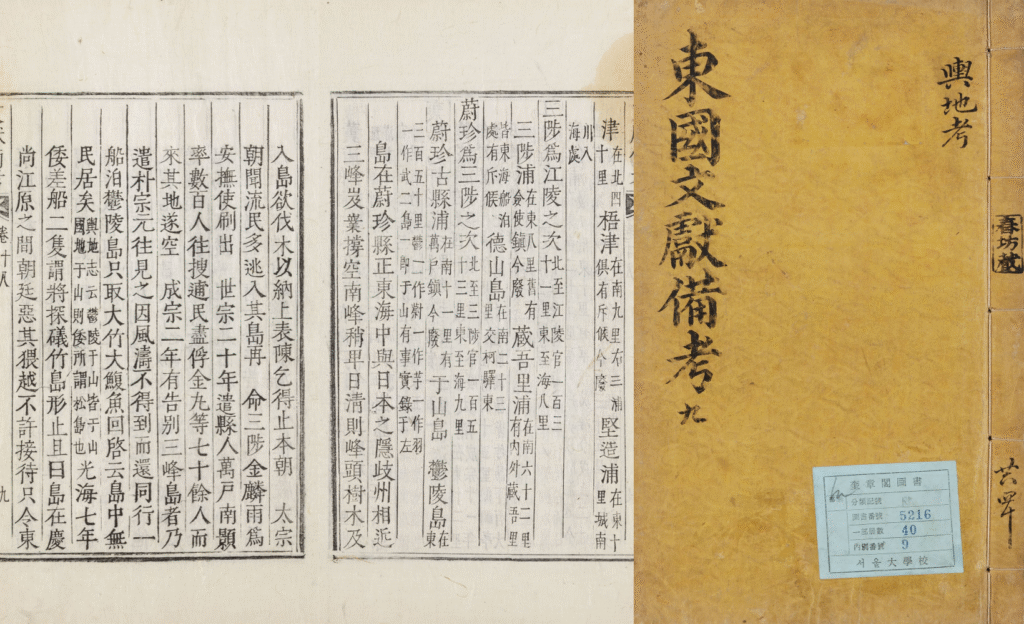
which includes a description of Usan-guk and Usan-do (Dokdo)
*source: Kyujanggak Institute for Korean Studies, Seoul National University
1779 Revised Complete Map of Japanese Lands and Roads (改正日本輿地路程全圖)
The Revised Complete Map of Japanese Lands and Roads (改正日本輿地路程全圖) was created in 1779 by Nagakubo Sekisui (長久保赤水), a Confucian scholar during the Edo period of Japan, with the official permission of the shogunate. In the first edition published in 1779 and in subsequent versions, territories of Joseon including Dokdo, Ulleungdo and Busan are shown without color, unlike Japanese territory, and are placed outside the lines of longitude and langitude used to define Japan’s domain. This clearly distinguishes them from Japanese territory.
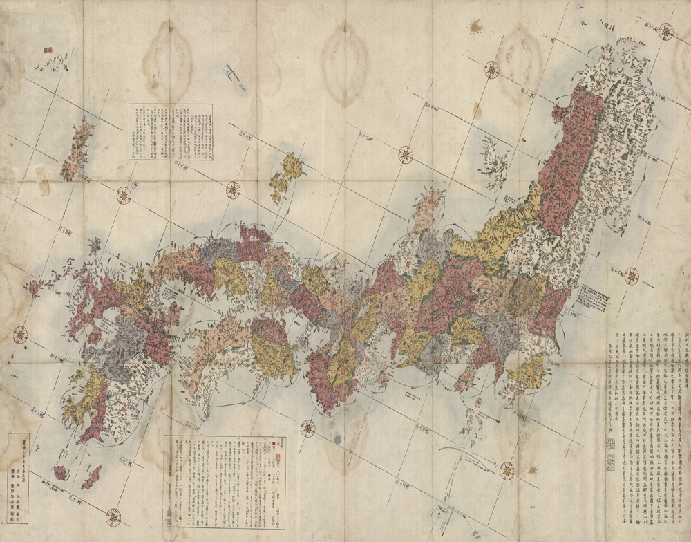
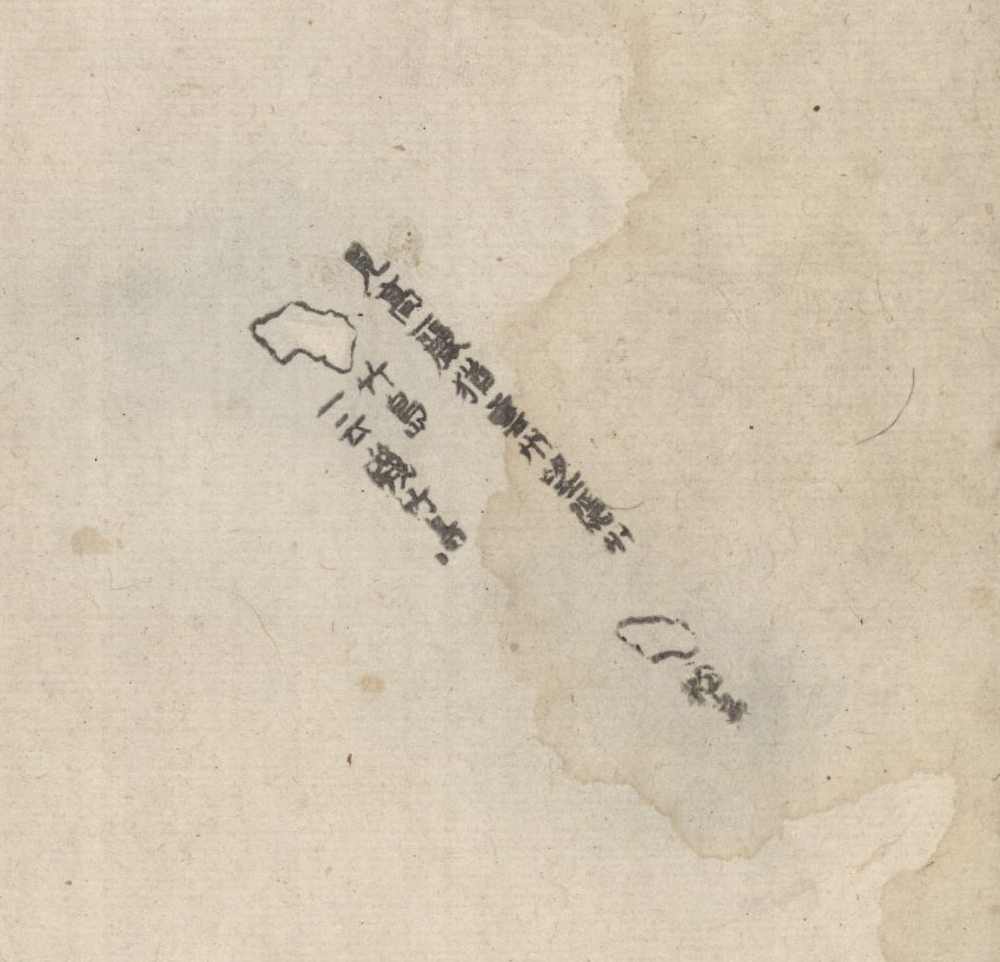
Revised Complete Map of Japanese Lands and Roads (1791 edition)
with a close-up of the Ulleungdo and Dokdo section
*source: Dokdo, Ministry of Foreign Affairs, Republic of Korea
Also, next to Dokdo and Ulleungdo on this map, there is a quote from Records on Observations in Oki Province (隠州視聴合記), which shows that the map was based on this document. It recognized Dokdo and Ulleungdo as part of Joseon and set the northwestern boundary of Japan at Oki Island. This indicates that the map also recognized Dokdo and Ulleungdo as Joseon territory.
[translation]
Takeshima [Ulleungdo], also known as Isotakeshima
Matsushima [Dokdo]
The two islands are located towards Goryeo [Korea] in the same way that Unshu [eastern part of today’s Shimane Prefecture] is located towards Inshu [Oki Islands of Japan]
[original text]
竹島—云磯竹島
松島
見高猶雲州望隠州
Revised Complete Map of Japanese Lands and Roads
* At the time, Japan called Dokdo Matsushima (Songdo / 松嶋 or 松島) and Ulleungdo Takeshima (Jukdo / 竹嶋 or 竹島).
1794 Jeongjo Sillok (正祖實錄, Annals of King Jeongjo)
In the 18th year of King Jeongjo’s reign in Joseon (1794), it was recorded that Han Chang-guk (韓昌國), the naval commander of the Uljin area and Wolsong Manho (越松萬戶) at the time, who had traveled as a patrol officer, captured two sea lions on Dokdo after inspecting Ulleungdo and sent the sea lion skins to the Bibyeonsa (Border Defense Council).
[translation]
“It was stated that ‘The inspection of Ulleungdo is to be carried out every two years by border commanders in rotation, as already established. Therefore, orders were given to Wolsong Manho
Han Chang-guk, the patrol officer.’ (omitted)
On the 26th, they turned toward Gaji Island. Four to five sea lions suddenly leapt out in alarm, appearing like water buffalo. The gunners fired all at once and captured two. (omitted)
On the 30th, they set sail and returned to the garrison on the 8th. It was reported that the items collected on the island included: two sea lion skins, three bamboo stalks, two bundles of sandalwood, five seung of cinnabar from between the rocks, and one map. These were sealed and submitted to the Bibyeonsa.
[original text]
鬱陵島搜討, 間二年, 使邊將輪回擧行, 已有定式, 故搜討官越松萬戶韓昌國處, 發關分付矣。(중략)
二十六日轉向可支島, 四五箇可支魚, 驚駭躍出, 形若水牛。 砲手齊放, 捉得二首 (중략)
三十日發船, 初八日還鎭。 島中所産可支魚皮二令、篁竹三箇、紫檀香二吐莫、石間朱五升、圖形一本, 監封上使” 云。 幷上送于備邊司。
Annals of King Jeongjo, Volume 40, June 3rd, the 18th year of King Jeongjo’s reign (1794), 9th entry for the day (Muo)
Report by Sim Jin-hyeon (沈晉賢), Governor of Gangwon-do
which contains the record of the 1794 inspection and patrol activities
*source: The Veritable Records of the Joseon Dynasty, National Institute of Korean History
1795 Inbanji (因幡誌)
It is a geographical record of Tottori-han in Japan, compiled by Abe Kyoan (安部恭庵), a physician in Tottori-han.
The book explains the meaning of the phrase 朝鬱兩島 that was written on the flag used by Ahn Yong-bok during his second landing in Japan in 1696. According to the book, 朝鬱兩島 refers to Ulleungdo and Usando— two islands that Ahn claimed as belonging to Joseon. The book claims that Usando (子山嶋) of Joseon was known in Japan as Matsushima (松嶋), the name Japan used for Dokdo at the time. This clearly confirms that Usando corresponds to present-day Dokdo.
For reference, during the second landing in Japan in 1696, Ahn Yong-bok is said to have raised a flag on his boat that read 朝鬱兩島監稅將臣安同知騎, meaning ‘A Joseon official overseeing taxation and administration of the two islands, Ulleungdo and Usando. Official Ahn, Assistant Governor on Horseback’.
[translation]
The two islands of Ulleung and Usan of Joseon are Ulleungdo (called Takeshima in Japan) and Usando (Usanseom, called Matsushima in Japan).
[original text]
朝欝両島ハ 欝陵嶋(日本ニテ是ヲ竹嶋ト称ス) 于山嶋(ウサンスム 日本ニテ松嶋ト呼)是ナリ
Inbanji
* At the time, Japan called Dokdo Matsushima (松嶋 or 松島).
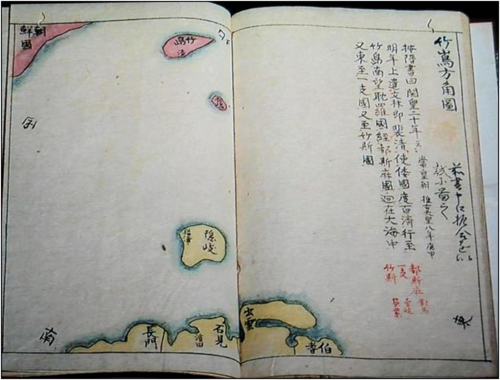
1836 Jukdo Banggakdo (竹島方角圖)
In 1693, following Ahn Yong-bok’s actions and diplomatic discussions between Joseon and Japan, the Edo shogunate officially recognized that Ulleungdo and Dokdo are not part of its territory. As a result, in 1696, the shogunate issued a ban on sea passage (渡海禁止令) to the Ulleungdo area, effectively prohibiting access by the Japanese people.
However, between 1833 and 1836, a Japanese man named Aizuya Hachiemon (会津屋八右衛門) secretly engaged in smuggling around Ulleungdo and Dokdo without the shogunate’s permission. In 1836, he was sentenced to death for leaving the country without authorization. During his investigation, a map he personally drew called Jukdo Banggakdo (竹島方角圖) showed Japanese territories, including Oki Island, colored in yellow, while Ulleungdo and Dokdo were colored red, the same as Korean land. This shows that even at that time, Hachiemon and other Japanese people still recognized Dokdo as Korean territory.
*source: Dokdo Research Series 21, Dokdo Institute, Yeungnam University
1857 East Coast of Korea (Восточный берег полуострова Кореи)
In 1854, people on the Russian Navy’s Olivutsa (Опивуца), a vessel belonging to the frigate Pallada (Фрегат Паллада), discovered Dokdo and created an illustration of Dokdo. Based on this observation, the Russian Navy’s Hydrographic Service later published a map titled East Coast of Korea (Восточный берег полуострова Кореи).
This is the map in which Dokdo was shown for the first time in the West as two separate islets. Seodo, the west islet, was labeled Olivutsa (Опивуца) and Dongdo the east islet, was marked Menelai (Менелай)—the former name of the ship.
*source: Northeast Asian History Foundation
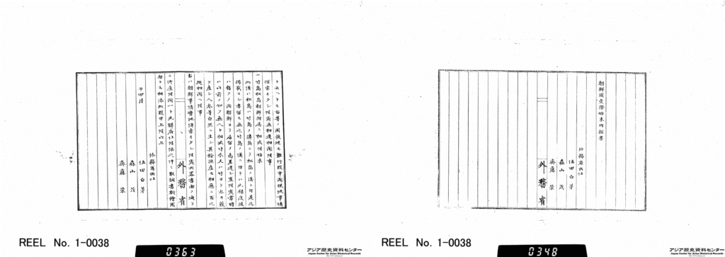
1870 Confidential Inquiry into the Particulars of Relations with Joseon (朝鮮國交際始末內探書)
In 1870, during the early years of the Meiji government of Japan (January 3, 1868 – July 30, 1912), Japan sent officials from the Ministry of Foreign Affairs to Joseon to gather information in preparation for a possible invasion. These officials were tasked with investigating Joseon’s diplomatic affairs, military strength, trade, ports and other matters.
The report they submitted upon returning to Japan, titled Confidential Inquiry into the Particulars of Relations with Joseon (朝鮮國交際始末內探書), includes a section called “How Ulleungdo and Dokdo became part of Joseon”. This clearly shows that Japan recognized Dokdo as Joseon territory at the time.
[translation]
1. The background to how Takeshima (Ulleungdo) and Matsushima (Dokdo) became annexed to Joseon
Matsushima [Dokdo] is an island next to Takeshima [Ulleungdo]. No records regarding Matsushima exist, but letters exchanged in the late seventeenth century include comments relating to Takeshima [Ulleungdo]. For some time since the late seventeenth century, Joseon had sent people to reside in Takeshima [Ulleungdo], but now it has become an uninhabited island again. It is hard that bamboo, reeds that are thicker than bamboo, and ginseng grow there. Fish may be caught, too. This record is based upon our local investigation. We will report this together with our investigation documents, illustrations, and maps by topic after returning to Japan.
The diplomatic mission of Sada Hakubo, Moriyama Shigeru, and Saito Sakai in April, 1870
[original text]
一. 竹島松島朝鮮附屬ニ相成候始末
此儀松島ハ竹島ノ隣島ニチ松島ノ儀ニ付是迄揭載セシ書留モ無之. 竹島ノ儀ニ付テハ元祿度後ハ暫クノ間朝鮮ヨリ居留ノ爲差遣シ置候處當時ハ以前ノ如ク無人ト相成竹木又ハ竹ヨリ太キ葭ヲ産シ人參等自然ニ生シ其餘漁産モ相應ニ有之趣相聞ヘ候事.
右ハ朝鮮事情實地偵索イタシ候大略書面ノ通リニ御座候間一ト先歸府仕候依之件々取調書類繪圖面トモ相添此段申上候以上.
午 四月 外務省出仕 佐田白茅 森山茂 齎藤榮
Confidential Inquiry into the Particulars of Relations with Joseon
* At the time, Japan called Dokdo Matsushima (Songdo / 松嶋 or 松島) and Ulleungdo Takeshima (Jukdo / 竹嶋 or 竹島).
focusing on the sections about Ulleungdo and Dokdo
*source: Japan Center for Asian Historical Records, National Archives of Japan
“1. 1870(1)/Vol. 4/1 From 28 January, 1870 to April, 1870”
Japan Center for Asian Historical Records (JACAR) Ref.B03030163900, Collection of the documents relevant to the policy towards Korea/Management paper for the Korean issues Vol. 2 (1-1-2-3_13_002) (Diplomatic Archives of the Ministry of Foreign Affairs)
Later, in 1875, the Japanese government provoked the Unyo Incident near Ganghwado and Yeongjongdo in Korea, where the Japanese ship Unyo (雲楊號) opened fire. Then, in 1876, under military pressure, Japan forced the Joseon government to sign an unequal treaty called the Korea-Japan Commercial Treaty of Amity (朝日修好條規, also known as the Treaty of Ganghwa), compelling Joseon to open its ports. This marked the beginning of Joseon’s full-scale aggression toward Korea.
1875, 1876 East Coast of Korea (朝鮮東海岸圖)
In 1875, the Japanese Navy produced a Japanese-language version of the East Coast of Korea, originally created by the Russian Navy in 1857. In doing so, they followed the same assessment as Russia and included Dokdo as part of Korea on the map.
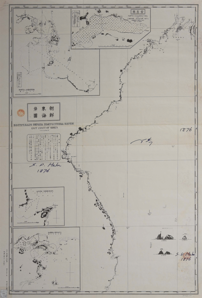
*source: Digital Library, National Assembly Library
1877 Complete Map of Japan (大日本全圖)
This official Japanese map, produced in 1877 by the Land Survey Department of the Army General Staff Office under Japan’s Meiji government—the country’s modern surveying and map-making agency at the time—does not include Dokdo.
The spot where Dokdo should be is left blank, showing that Japan still did not recognize Dokdo as part of its territory.
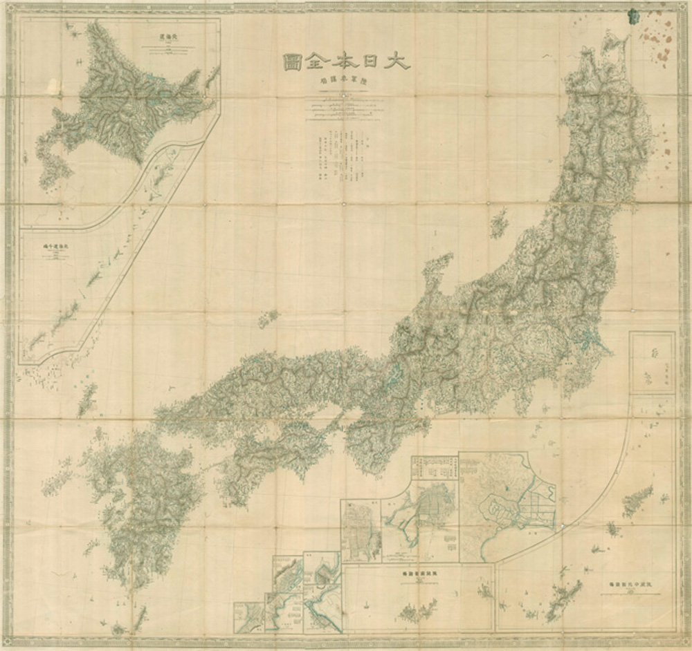
*source: Dokdo, Ministry of Foreign Affairs, Republic of Korea
1877 Inquiry by the Ministry of Home Affairs of Japan on the Territorial Status of Dokdo
After the Meiji Restoration in 1868, the Ministry of Home Affairs of Japan (内務省)—the predecessor of present-day Ministry of Internal Affairs and Communications of Japan and similar to the Ministry of the Interior and Safety in Korea—began a modern land registry project in 1876. During this process, the question arose as to whether Ulleungdo and its associated island, Dokdo, should be included as part of Japanese territory.
In 1876, Shimane Prefecture sent an inquiry to the Ministry of Home Affairs of Japan about including Ulleungdo and Dokdo in the map of the prefecture. After conducting its own investigation—referencing events such as the Ahn Yong-bok incident in the 1690s and the prohibition on sea passage by the Tokugawa Shogunate—the Ministry of Home Affairs of Japan tentatively concluded that the two islands had no relation to Japan.
The Ministry of Home Affairs of Japan reported its position to the Dajokan (太政官), the highest administrative body of the Japanese government at the time and the predecessor of present-day Prime Minister’s Office of Japan, stating that it would handle the matter under the assumption that the islands were not related to Japan. However, the Dajokan responded that “territorial issues are matters of national importance, so a formal inquiry is required”. On March 17, 1877, the Minister of Home Affairs of Japan
(内務卿, now 内務大臣), Okubo Toshimichi (大久保利通), submitted an official written inquiry to the Dajokan, formally asking whether Ulleungdo and Dokdo should be included as Japanese territory.
[translation]
Inquiry Regarding the Compilation of Land Registers for Takeshima and One Other Island
Attached is an inquiry from the Ministry of Home Affairs concerning the compilation of land registers for Takeshima and one other island in the Sea of Japan. Regarding this matter, it has been stated that since Koreans first landed on the island in the 5th year of Genroku (1692), the former government corresponded back and forth with that country (Joseon), and it was ultimately confirmed that the islands have no relation to Japan. Based on this statement, we ask whether we may proceed as instructed below, having noted the content of the inquiry.
(omitted)
Next, there is one island called Matsushima.
[original text]
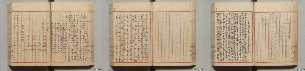
竹嶋外一嶋地籍編纂方伺
別紙内務省伺日本海内竹嶋外一嶋地籍編纂之件右ハ元禄五年朝鮮人入嶋以来旧政府該国ト往復之末遂ニ本邦関係無之相聞候段申立候上ハ伺之趣御聞置左之通御指令相成可然哉此段相伺候也
(중략)
次ニ一島アリ松島ト呼フ
On March 17, 1877, Japan’s Ministry of Home Affairs inquired with the higher authority, the Dajokan, about the jurisdiction over Ulleungdo and Dokdo.
* At the time, Japan called Dokdo Matsushima (Songdo / 松嶋 or 松島) and Ulleungdo Takeshima (Jukdo / 竹嶋 or 竹島).
Japan’s Ministry of Home Affairs to inquire about the jurisdiction of Dokdo
*source: Digital Archive, National Archives of Japan
March 29, 1877 Dajokan Order (太政官 指令)
After receiving the inquiry from the Ministry of Home Affairs of Japan, the Dajokan reviewed the matter and agreed with the Ministry’s conclusion that Ulleungdo and Dokdo were not related to Japan. Accordingly, on March 29, 1877, the Dajokan issued an official directive to the Ministry of Home Affairs of Japan under the Minister of the Right (右大臣) Iwakura Tomomi (岩倉具視)—a government position equivalent to present-day Deputy Prime Minister. The directive clearly stated:
[translation]
Directive
Regarding Takeshima [Ulleungdo] and one other island [Dokdo] about which an inquiry was submitted, bear in mind that our country [Japan] has nothing to do with them.
[original text]
御指令按
伺之趣竹島外一嶋之義本邦関係無之義ト可相心得事
On March 29, 1877, Japan’s Dajokan issued an order to the Ministry of Home Affairs stating that Ulleungdo and Dokdo are not related to Japan.
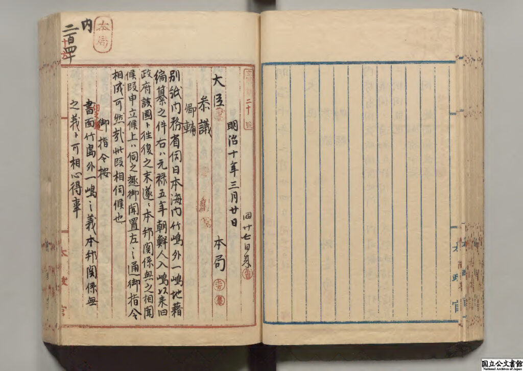
*source: Digital Archive, National Archives of Japan
This was an official document in which the highest administrative body of Japan at the time explicitly acknowledged that Dokdo is not Japanese territory. On April 9, 1877, this was again conveyed to Shimane Prefecture through the Ministry of Home Affairs of Japan with the instruction: “Do not include Ulleungdo and Dokdo as part of the territory of Shimane Prefecture”.
1877 Simplified Map of Isotakeshima (磯竹島略圖)
The fact that the “one island besides Ulleungdo” (一嶋) mentioned in the Dajokan Order refers to Dokdo can be confirmed through the official document from the Ministry of Home Affairs of Japan that inquired about the ownership of Ulleungdo and Dokdo. It is also clearly shown in the map attached to the Dajokan Order, where the island next to Ulleungdo (in the center of the map) is labeled with the name Matsushima (松島), which was the name Japan used for Dokdo at the time. This confirms that the “one island” other than Ulleungdo is indeed Dokdo.
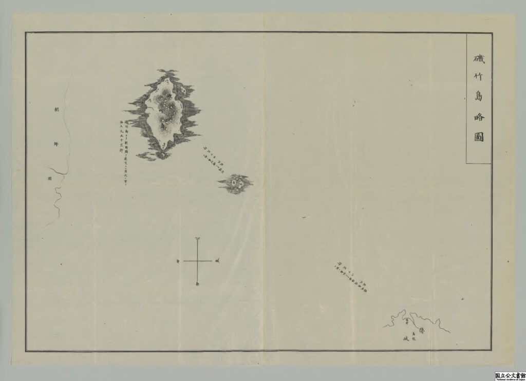
*source: Digital Archive, National Archives of Japan
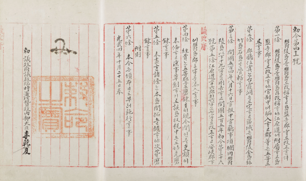
October 25, 1900 Imperial Decree No. 41 (勅令 第四十一號)
Despite the Japanese government’s bans in 1696 and 1837 prohibiting Japanese people from passing the sea to go to Ulleungdo, illegal settlement and resource exploitation by Japanese people in the Ulleungdo area expanded during the late 19th century.
To overcome Japan’s wrongdoings and strengthen governmental administration over Ulleungdo and its surrounding areas, Emperor Gojong of the Korean Empire (Daehan Jeguk) issued an imperial decree on October 25, 1900. Through his decree, he changed the name of Ulleungdo—which was one of the islands under Uljin-hyeon in Gangwon-do at the time—to ‘Uldo-gun’, and officially designated Dokdo, an island affiliated with Ulleungdo, as part of the jurisdiction of Uldo-gun.
[translation]
The Renaming of Ulleungdo to Uldo and the promotion of the post of inspector [dogam] to county magistrate [gunsu]
Article 1. Ulleungdo shall be renamed Uldo and shall fall under the jurisdiction of Gangwon-do [Gangwon Province]
The post of inspector [dogam] shall be promoted to county magistrate [gunsu] and incorporated into officialdom, and the county shall be a class 5 county
Article 2. The county office shall be located in Taehadong, and as regards its districts, all of Ulleungdo as well as Jukdo and Seokdo [Dokdo] shall be placed under the jurisdiction of Uldo-gun (Uldo county).
[original text]
鬱陵島를 鬱島로 改稱ᄒᆞ고 島監을 郡守로 改正件
第一條 鬱陵島를 爵島라 改稱ᄒᆞ야 江原道에 附屬ᄒᆞ고 島監을 郡守로 改正ᄒᆞ야 官制中에 編入ᄒᆞ고 郡等은五等으로ᄒᆞㄹ 事
第二條 郡廳位置 台霞洞으로 定ᄒᆞ고 區域은 鬱陵全島와 竹島石島 管轄ᄒᆞㄹ 事
Imperial Decree No. 41
* Due to input issues with old Korean script, some characters are being displayed as “”.
*source: Kyujanggak Institute for Korean Studies, Seoul National University
This imperial decree, which became the origin of “Dokdo Day” celebrated on October 25, was officially announced and widely publicized through the Official Gazette of the Korean Empire two days later, on October 27, 1900.
October 27, 1900 Official Gazette Issue No. 1716 (官報 第一千七百十六號)
The Official Gazette of the Korean Empire, Issue No. 1716, published on October 27, 1900, includes the full text of Imperial Decree No. 41. This decree, established on October 25, 1900, officially elevated Ulleungdo to the status of Uldo-gun and designated Dokdo as part of its jurisdiction.
*source: Kyujanggak Institute for Korean Studies, Seoul National University
1901 The History of Modernization of Joseon (朝鮮開化史)
The History of Modernization of Joseon (朝鮮開化史) is a book written by a Japanese person named Tsuneya Seifuku (恒屋盛服), who stayed in Korea and served as an advisor at the Government Gazette Bureau—an agency established under Uijeongbu (the State Council) during the Gabo Reform in June 1894.
In this book as well, consistent with previous understanding, Usando (Dokdo) is mentioned as an attached island of Ulleungdo, and Usando is introduced as “Matsushima (松島)”, which was Japan’s name for Dokdo at the time.
[translation]
Ulleungdo (omitted)
There are six large and small islands, among which the well-known ones are Usando (called Matsushima by the Japanese) and Takeshima.
[original text]
欝陵島 (중략)
大小六島アリ 其中著名ナルヲ 于山島 (日本人ハ松島ト名ク) 竹島ト云
main text of the section on Ulleungdo in The History of Modernization of Joseon
* At the time, Japan called Dokdo Matsushima (Songdo / 松嶋 or 松島), Yanko Island (ヤンコ島), Liancourt Rocks (リアンクルド岩), and so on.
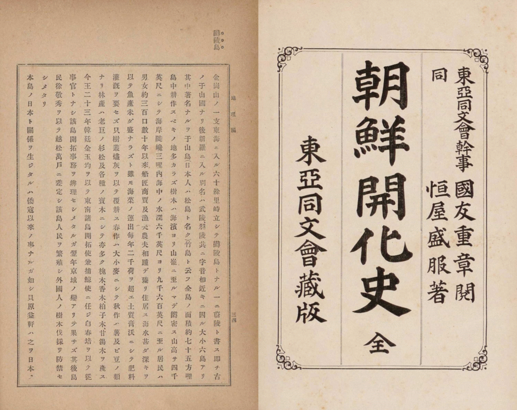
*source: National Library of Korea
January 4, 1903 Guidelines for Fisheries in the Korean Sea (韓海通漁指針)
The Guidelines for Fisheries in the Korean Sea is a book compiled by Kujo Shusuke (葛生修亮), a member of the Japanese right-wing organization Black Dragon Society (黒龍会), based on his investigation of the coastal geography and fishing conditions of Korea.
In this book, the contents about Dokdo are included under the section on Ulleungdo, Korea, which shows that Japan continued to recognize Dokdo as an island belonging to Ulleungdo, Korea at the time.
[translation]
(Table of Contents) (4) Gangwon-do – Ulleungdo (Yanko Island)
(Main Text) (4) Gangwon-do
◎ Ulleungdo
△ Yanko Island ··· On clear days, it can be seen from the high peaks of Ulleungdo ···
[original text]
(目次) (四) 江源道 欝陵島 (ヤンコ島)
(本文) (四) 江源道
◎ 欝陵島
△ ヤンコ島 ··· 晴天の際欝陵島山峯の高所より之れを望むを得べし ···
Guidelines for Fisheries in the Korean Sea
* At the time, Japan called Dokdo Yanko Island (ヤンコ島), and so on.
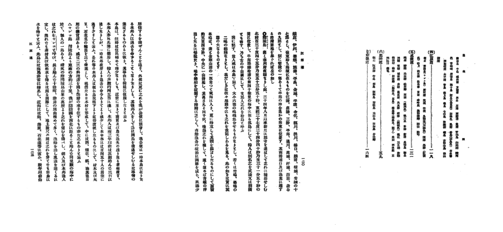
which includes explanations related to Ulleungdo and Dokdo
*source: National Assembly Library
February 22, 1905 Shimane Prefectural Notice (島根縣 告示) No. 40
In 1905, during its war with Russia over interests in Manchuria and the Korean Peninsula, Japan unilaterally claimed that Dokdo was a land without an owner and, without Korea’s knowledge, announced it as part of Shimane Prefecture for military purposes.
[translation]
Shimane Prefectural Notice No. 40
The islands at 37°9’30” north latitude and 131°55′ east longitude located 85 nautical miles northwest of the Oki Islands are hereby named Takeshima, and shall come under the jurisdiction of the Oki Islands Branch Office of this prefecture.
February 22, Meiji 38 (1905)
Matsunaga Takekichi, Governor of Shimane Prefecture
[original text]
島根縣告示第40號
北緯三十七度九分三十秒東經百三十一度五十五分隱岐島ヲ距ル西北八十五浬二在ル島嶼ヲ竹島ト稱シ
自今本縣所屬隱岐島司ノ所管ト定メラル
明治三十八年 二月二十二日
島根縣知事 松永武吉
Shimane Prefectural Notice No. 40
However, at the time—and ever since—Dokdo has remained Korean territory, and the Shimane Prefectural Notice was merely an illegal, unilateral attempt to incorporate the island without the knowledge of Korea, which held sovereignty over it.
In particular, this notice was never published in the official gazette of the Japanese government, nor it was reported by any of Japan’s 104 newspapers at the time. Japan’s illegal action went completely unnoticed both within Japan and abroad, including in Korea.
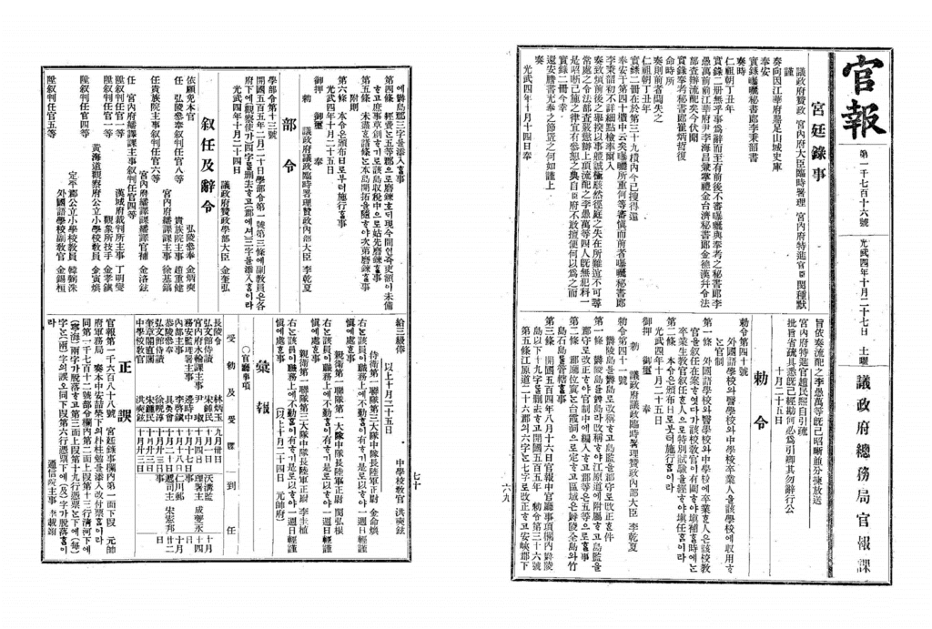
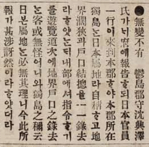
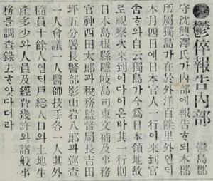
March 29, 1906 Special Report by County Magistrate of Uldo-gun (Supplementary Report 報告書 號外)
May 10, 1906 Directive No. 3 (指令 第三號) by Vice Minister of Uijeongbu
On March 28, 1906, Sim Heung-taek, the County Magistrate of Uldo-gun (present-day Ulleung-gun), heard a one-sided claim by the delegation from Shimane Prefecture in Japan, which had visited Ulleungdo, stating that Japan had incorporated Dokdo into its territory. The next day, on March 29, 1906, Sim submitted a report to the official of Gangwon-do, alerting him to the illegal encroachment by Japan.
In the report, Sim explained “Dokdo, which belongs to this county (Uldo-gun, now Ulleung-gun)”, thereby affirming the territorial sovereignty of Korea over Dokdo, as had already been clearly designated in Imperial Decree No. 41 of the Korean Empire, which placed Dokdo under the jurisdiction of Uldo-gun.
Following Sim’s report, Yi Myeong-rae, acting Governor of Gangwon-do and County Magistrate of Chuncheon at the time, submitted a further report on April 29, 1906, to the Uijeongbu (State Council), the highest administrative body of the Korean Empire.
[translation]
Special Report
Report by Sim Heung-taek, Governor of Ulleung County
As stated in the contents of this report, the island of Dokdo, which belongs to this county, lies over one hundred ri offshore from the mainland. On the morning of the 4th of this month, a Japanese ship anchored at Dodong Port within the county, and a group of Japanese officials came to the county office. They claimed that Dokdo is now Japanese territory and that they were here to inspect it.
The group consisted of the following members: Higashi Bunpu, Governor of Oki Island, Shimane Prefecture; administrative official Kamizai Yutaro; Director of the Tax Supervision Bureau Yoshida Heigo; Branch Chief and Police Inspector Kageyama Ganpachiro; one police officer; one assembly member; and one doctor and one technician, along with more than ten attendants.
They first inquired about the total number of households and population, land area, and production. They also asked about personnel and expenses, and recorded various administrative matters as part of their investigation.
I respectfully submit this report and ask for your consideration and direction.
April 29, 1906
Sim Heung-taek, Governor of Ulleung County
Lee Myeong-rae, Acting Governor of Gangwon Province and Governor of Chuncheon County
To: His Excellency, Minister of State Affairs, Uijeongbu
[original text]
報告書 號外
鬱島郡守 沈興澤 報告書 內開에 本郡所屬 獨島가 在於本部外洋百餘里外이삽더니 本月初四日辰時量에 輪船一雙이 來泊于郡內道洞浦而 日本官人一行이 到于官舍ᄒᆞ야 自云獨島가 今爲日本領地故로 視察次來到이다 이온바 其一行則 日本島根縣隱岐島司東文輔及 事務官神西由太郞 稅務監督局長吉田平吾 分署長警部 影山巖八郞 巡査一人 會議員一人 醫師技手各一人 其外隨員十餘人이 先問戶摠人口土地生産多少ᄒᆞ고 且問人員及經費幾許 諸般事務를 以調査樣으로 錄去이ᄋᆞᆸ기 玆에 報告ᄒᆞ오니 照亮ᄒᆞ시믈 伏望等因으로 准此報告ᄒᆞ오니 照亮ᄒᆞ시믈 伏望.
光武十年 四月二十九日
江原道觀察使署理春川郡守 李明來
議政府參政大臣 閣下
Report by Sim Heung-taek, Governor of Ulleung County, and Acting Governor of Gangwon Province, Lee Myeong-rae
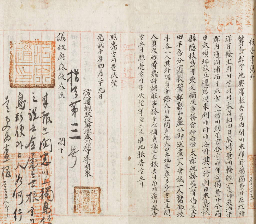
and the directive from the Vice Minister of the Uijeongbu in response
*source: Kyujanggak Institute for Korean Studies, Seoul National University
On May 10, 1906, after receiving this report, Park Je-sun, Vice Minister of the Uijeongbu, did not acknowledge or accept Japan’s claim. Instead, he issued a directive stating that the claim that Dokdo belonged to Japan had no basis and ordered a reinvestigation and a follow-up report.
[translation]
Directive No. 3
The report has been reviewed and acknowledged. The claim that Dokdo is Japanese territory is completely baseless. Further investigation will be conducted regarding the island’s shape, location, and the actions of the Japanese.
May 10
[original text]
指令 第三號
來報 閱悉이고 獨島領地之說은 全屬無根니 該島 形便과 日人 如何 行動을 更爲査報ᄒᆞㄹ 事
五月十日
Directive No. 3 from the Vice Minister of the Uijeongbu regarding the report from the Governor of Uldo County
* Due to input issues with old Korean script, some characters are being displayed as “□”.
And Korean newspapers also reported and criticized these outrageous acts by Japan.
[translation]
An Incident Has Occurred
Uldo County (Ulleungdo) Magistrate Sim Heung-taek reported to the Ministry of Internal Affairs that a group of Japanese officials had visited the county and claimed that Dokdo, which belongs to the county, was a Japanese dominion and that they had gone here and taken a census of the population and a survey of farmland. The Ministry instructed that it would not be entirely unusual that they roamed the area and took a census since they were sightseeing, but it is entirely groundless for them to refer to Dokdo as a Japanese dominion, and thereby, the report left them shocked.
[original text]
無變不有
鬱島郡守沈興澤氏가 府에 報告되 日本官員一行이 來到本郡야 本郡所在獨島 日本屬地라 自稱고 地界濶狹과 戶口結摠을 一一錄去라ᄒᆞ얏 내部에셔 指令기를 遊覽道次에 地界戶口之錄去 客或無怪어니와 獨島之稱云日본屬地 必無其理니 今此所報가 甚涉訝然이라ᄒᆞ얏더라
“An Incident Has Occurred”, article, Daehan Maeil Shinbo, May 1, 1906
* Due to input issues with old Korean script, some characters are being displayed as “□”.
(left) “An Incident Has Occurred”, article, Daehan Maeil Shinbo, May 1, 1906
(right) cover and main text of Daehan Maeil Shinbo, May 1, 1906
*source: Korea Newspaper Archive, National Library of Korea
[translation]
Ulswi-Bogo-Naebu (The Uldo Magistrate Reports to the Ministry of Internal Affairs)
Uldo County (Ulleungdo) Magistrate Sim Heung-taek reported to the Ministry of Internal Affairs that
“Dokdo, which is under the jurisdiction of this county, is some 100 li (39km) out at sea. On the 4th of this month (March 28), a group of Japanese officials visited the county office and arbitrarily claimed, ‘Dokdo is now becoming a Japanese territory, so we have come to inspect the area.” The group included Oki Islands’ Magistrate Bunsuke Higashi of Shimane Prefecture; Secretary Yoshitaro Jinzai; Tax Office Superintendent Heigo Yoshida; Police Substation Captain Kanpachiro Kageyama; a policeman; a council member, a physician; an engineer; and some 10 others. They inquired about the number of households, size of the population, land area, and yields as well as the size of the staff and budget. They recorded the information as though they were undertaking a general survey and then left.
[original text]
鬱倅報告內部
●鬱倅報告內部 鬱島郡守沈興澤氏가 內部에 報告되 木郡所屬獨島가 在於外洋百餘里外인 本月四日에 日本官人一行이 來到官舍와 自云獨島가 今爲日本領地故로 視察次來到이다이온바 其一行則日本島根縣隱岐島司東文補及事務官神西田太郞과 稅務監督局長吉田坪五分署長警部影山岩八郞과 巡查一人會議一人醫師技手各一人其外隨員十餘人인 戶総人口와 土地生產多少와 人員及經費幾許와 諸般事務를 調查錄去ᄒᆞ얏다더라
“The Uldo Magistrate Reports to the Ministry of Internal Affairs, article, Hwangseong Shinmun,
May 9, 1906
* Due to input issues with old Korean script, some characters are being displayed as “□”.
(left) “The Uldo Magistrate Reports to the Ministry of Internal Affairs”,
article, Hwangseong Shinmun, May 9, 1906
(right) cover and main text of Hwangseong Shinmun, May 9, 1906
*source: Korea Newspaper Archive, National Library of Korea
However, unfortunately, at that time, the Korean Empire (Daehan Jeguk) had been forcibly stripped of its diplomatic rights and national sovereignty by Japan through the Japan-Korea Treaty of 1905 (also known as the Eulsa Treaty) on November 17, 1905. By February 1, 1906, Japan had established the Resident-General (with Ito Hirobumi as the first), which had taken control over the diplomacy and domestic affairs of the Korean Empire.
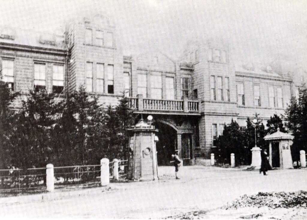
from February 1, 1906, to September 30, 1910, and prepared for Japan’s colonial rule.
On October 1, 1910, the Government-General of Korea, Japan’s colonial governing body that
succeeded all functions of the Resident-General, was established.
*source: Donga Digital Archive, Donga Ilbo
December 1, 1943 The Allied Powers, Cairo Declaration
Following Japan’s initiation of the Pacific War on December 18, 1941, the leaders of the United States, the United Kingdom and China held a summit in Cairo, Egypt, from November 22 to 26, 1943. On December 1, 1946, they issued a joint declaration demanding Japan to surrender and return its occupied territories, as well as promising the independence of Korea.
[original text]
Japan will be also be expelled from all her territories which she has taken by violence and greed.
Cairo Declaration
The official name is Declaration of the Three Powers-Great Britain, the United States and China regarding Japan
July 26, 1945 The Allied Powers, Potsdam Declaration
On July 26, 1945, the leaders of the United States, the United Kingdom and China gathered in Potsdam, Germany, and issued a declaration demanding Japan to surrender. In this declaration, they stated that
the sovereignty of Japan would be limited to the main islands of Honshu (本州), Hokkaido (北海道), Kyushu (九州) and Shikoku (四國), as well as other minor islands as determined by the Allied Powers.
Since then, Dokdo has never been included among the minor islands recognized by the Allied Powers as part of the territory of Japan.
[original text]
(8) The terms of the Cairo Declaration shall be carried out and Japanese sovereignty shall be limited to the islands of Honshu, Hokkaido, Kyushu, Shikoku, and such minor island as we (Allied Powers) determine.
Potsdam Declaration
The official name is Proclamation Defining Terms for Japanese Surrender
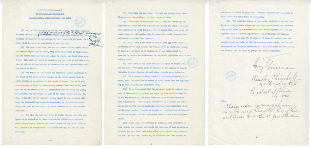
(excerpt above included in the center image)
*source: National Archives Catalog, U.S. National Archives and Records Administration
September 2, 1945 Japan signs the Instrument of Surrender
Japan signed the Instrument of Surrender, in which it pledged to faithfully carry out the terms of the Allied Powers’ Potsdam Declaration issued on July 26, 1945. This declaration specified that the sovereignty of Japan would be limited to the main islands of Honshu (本州), Hokkaido (北海道), Kyushu (九州) and Shikoku (四國), along with other minor islands to be determined by the Allied Powers.
[original text]
We (Japan), …hereby accept the provisions set forth in the declaration issued by the heads of the Government of the United States, China, and the Great Britain on 26, July, 1945 at Potsdam, … We hereby undertake for the Emperor, Japanese Government and their successors to carry out the provisions of the Potsdam Declaration in good faith.
Instrument of Surrender
Japan’s surrender document to the Allied Powers
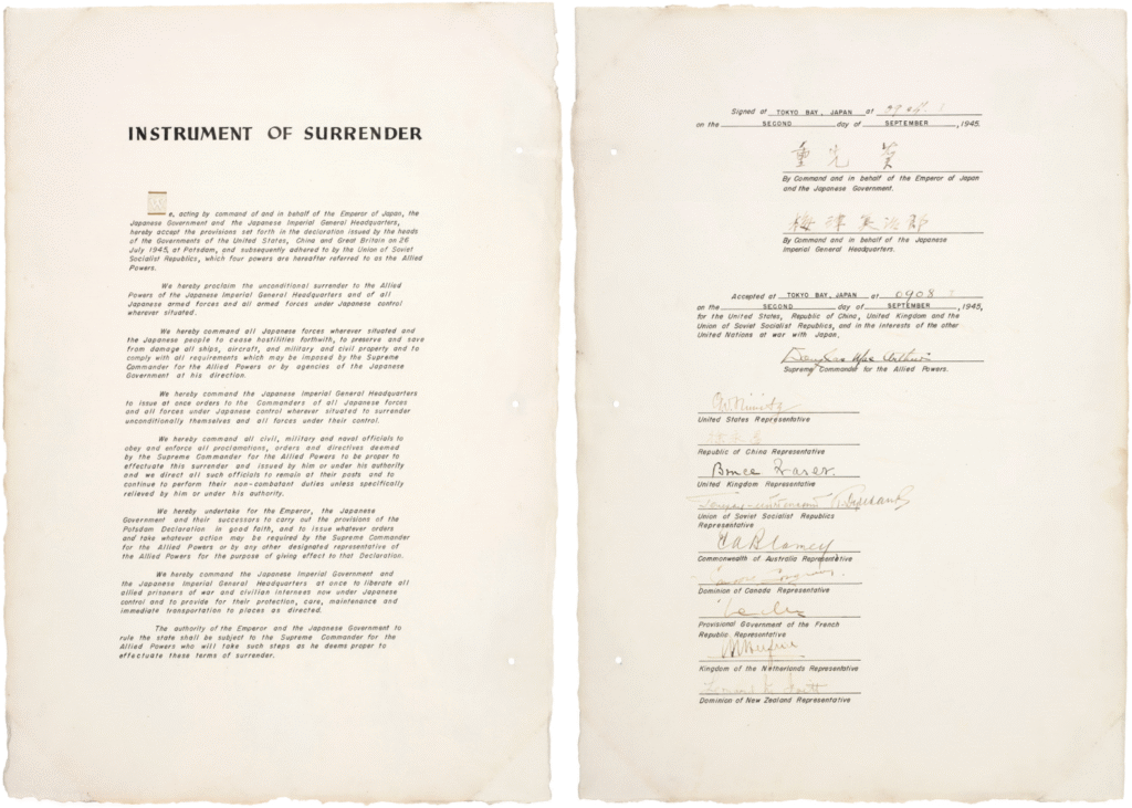
*source: National Archives Catalog, U.S. National Archives and Records Administration
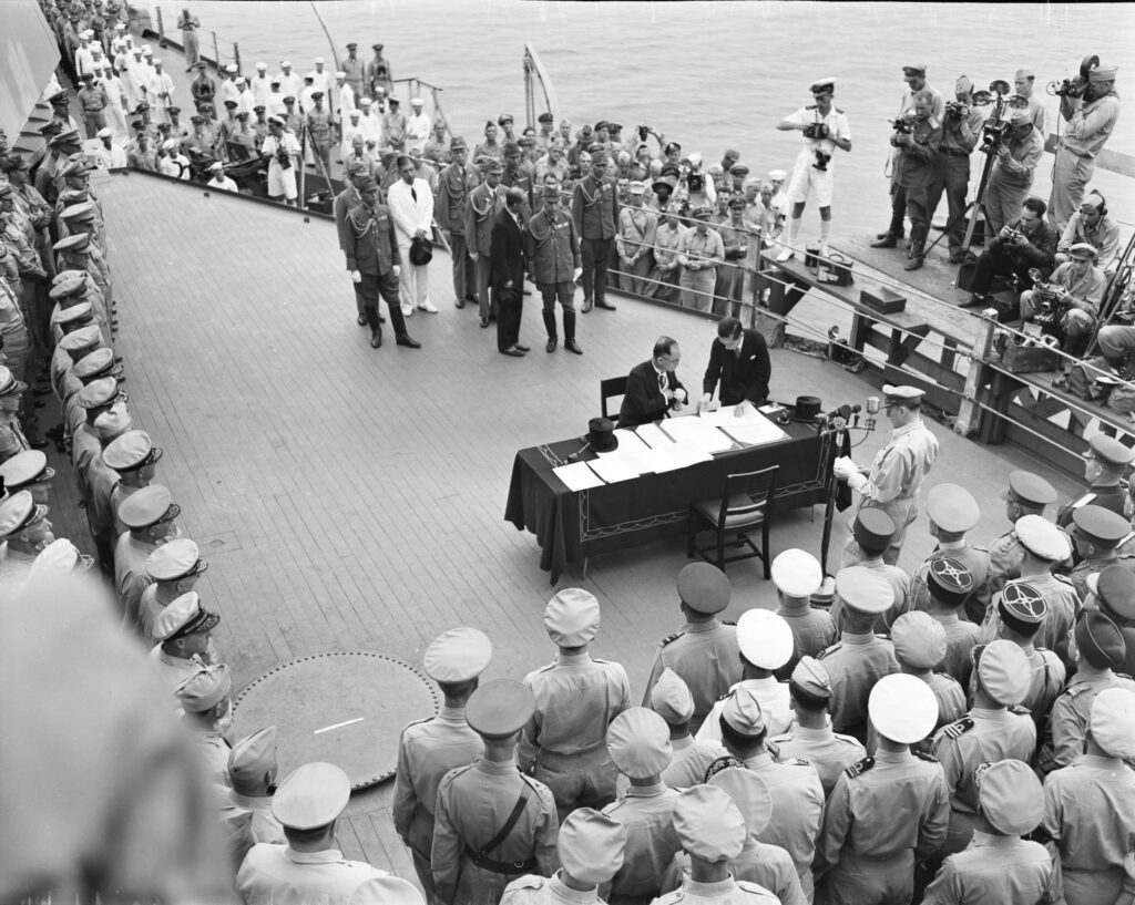
aboard the U.S. battleship USS Missouri.
The USS Missouri also participated in the Korean War, supporting the Hungnam evacuation operation from December 15 to 24, 1950, and was decommissioned in 1955.
[original caption] This historic surrender ceremony aboard USS Missouri (BB-63) Tokyo Bay.
Jap foreign minister, Namoru Shigemitsu, signs surrender terms as high ranking Allied officers look on. Gen. Douglas MacArthur, Supreme commander broadcasts the ceremonies.
*source: National Archives Catalog, U.S. National Archives and Records Administration
From September 2, 1945, when Japan signed the Instrument of Surrender, until April 28, 1952, when the San Francisco Peace Treaty came into effect. Japan was under the occupation and control of the Supreme Commander for the Allied Powers.
January 29, 1946 Supreme Commander for the Allied Powers Index No. 677 (SCAPIN-677)
The Supreme Commander for the Allied Powers, which was administering and occupying Japan after its surrender, excluded Dokdo from the territory of Japan through SCAPIN-677.
[original text]
3. For the purpose of this directive, Japan is defined to include the four main islands of Japan (Hokkaido, Honshu, Kyushu and Shikoku) and the approximately 1,000 smaller adjacent islands, including the Tsushima Islands and the Ryukyu (Nansei) Islands north of 30° North Latitude (excluding Kuchinoshima Island); and excluding (a) Utsuryo (Ullung) Island, Liancourt Rocks (Take Island *Dokdo) and Quelpart (Saishu or Cheju) Island, (b) the Ryukyu (Nansei) Islands south of 30° North Latitude (including Kuchinoshima Island), the Izu, Nanpo, Bonin (Ogasawara) and Volcano (Kazan or Iwo) Island Groups, and all the other outlying Pacific Islands [including the Daito (Ohigashi or Oagari) Island Group, and Parece Vela (Okino-tori), Marcus (Minami-tori) and Ganges (Nakano-tori) Islands], and (c) the Kurile (Chishima) Islands, the Habomai (Hapomaze) Island Group (including Suisho, Yuri, Akiyuri, Shibotsu and Taraku Islands) and Shikotan Island.
Supreme Commander for the Allied Powers Index No. 677
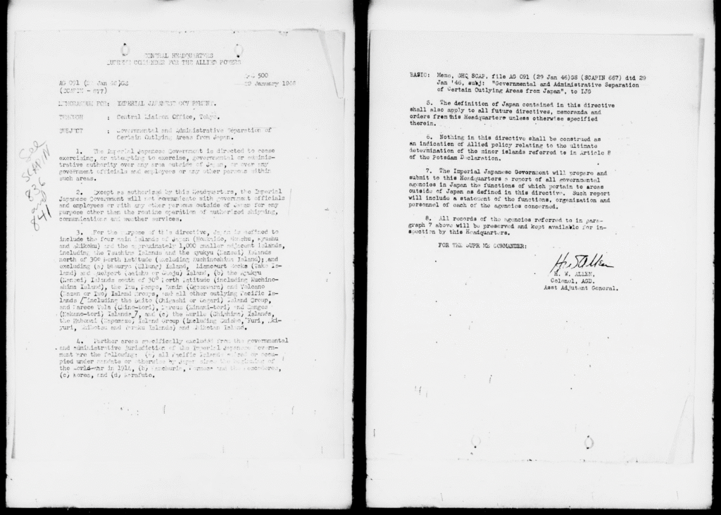
*source: NDL Digital Collections
June 22, 1946 Supreme Commander for the Allied Powers Index No. 1033 (SCAPIN-1033)
The Supreme Commander for the Allied Powers, after excluding Dokdo from the territory of Japan, went on to prohibit Japanese vessels and Japanese nationals from approaching Dokdo or entering within 12 nautical miles of the island.
[original text]
3. (b) Japanese vessels or personnel thereof will not approach closer than twelve (12) miles to Takeshima (*Dokdo) (37°15′ North Latitude, 131°53′ East Longitude) nor have any contact with said island.
Supreme Commander for the Allied Powers Index No. 1033
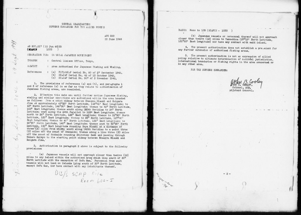
*source: NDL Digital Collections
August 20, 1947 Academic Survey of Dokdo
The Chosun Alpine Club, a civilian organization established on September 15, 1945—just a month after the liberation of Korea—launched a ‘National Land Identification Academic Survey Project’ with the aim of investigating the natural territory of Korea that had been violated under Japanese occupation.
In April 1947, a serious incident occurred when a Japanese fishing boat intruded into Dokdo and opened fire on Korean fishermen who were present on the island. In response, the interim government of Korea at the time began to take action, including conducting a survey of the Dokdo and Ulleungdo region.
The interim government organized the Dokdo Survey Team, consisting of six Korean public officials, and the Ulleungdo Scientific Research Team, made up of 63 experts from the Chosun Alpine Club. With the support of a U.S. Military Government patrol vessel, they conducted a scientific research of Ulleungdo from August 16 to 28, 1947, and visited Dokdo on August 20, 1947, to examine various aspects of the island and its surroundings, including geology, ocean currents, fisheries, and also collected plant and animal specimens.
At that time. Archer L. Lerch, the U.S. Army Military Governor of the U.S. Military Government in Korea, issued an official document ordering the six Korean public officials from the interim government to travel to Dokdo and Ulleungdo as part of the survey. This document confirms that the U.S. Military Government recognized Dokdo as being under Korean jurisdiction and administered it as such.
Afterward, the Chosun Alpine Club changed its name to the Corean Alpine Club on August 15, 1948, in line with the establishment of the administration of the Republic of Korea. The club went on to continue additional scientific research of Dokdo on September 22 and 24, 1952, and October 15, 1953.
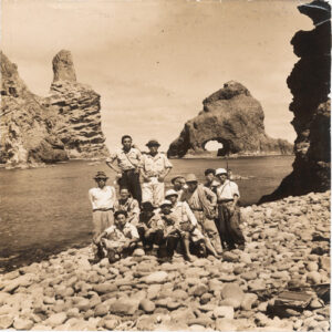
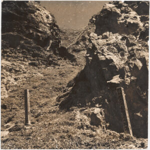
(left) Ulleungdo Scientific Research Team
(right) Dokdo signpost installed by the team
*source: Dokdo, Ministry of Foreign Affairs, Republic of Korea
[The Academy of Korean Studies, donated by Lee Sang-hyun of Corean Alpine Club]
September 2, 1951 San Francisco Peace Treaty (Treaty of Peace with Japan)
To settle matters regarding Japan’s actions during the Pacific War, a treaty was signed between Japan and the Allied Powers on September 2, 1951, in San Francisco, USA, and went to effect on April 28, 1952.
This treaty states that Japan recognizes the independence of Korea and will renounce all rights, titles and claims to Korea. It also specifies that Japan will acknowledge the validity of all actions taken by the Supreme Commander for the Allied Powers, which had occupied Japan. Japan signed this treaty.
[original text]
Article 2
(a) Japan recognizing the independence of Korea, renounces all right, title and claim to Korea, including the islands of Quelpart, Port Hamilton and Dagelet.
Article 19
(d) Japan recognizes the validity of all acts and omissions done during the period of occupation under or in consequence of directives of the occupation authorities or authorized by Japanese law at that time, and will take no action subjecting Allied nationals to civil or criminal liability arising out of such acts or omissions.
San Francisco Peace Treaty (Treaty of Peace with Japan)
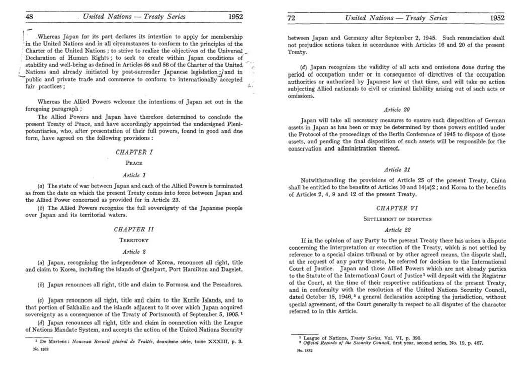
*source: United Nations Treaty Collection
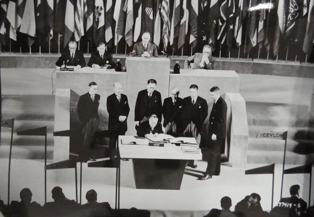
Japanese representative signing the Treaty of San Francisco
*source: National Archives Catalog, U.S. National Archives and Records Administration
In conclusion, after World War II, the Allied Powers decided to limit the territory of Japan to its four main islands and other small islands as determined by them. Japan accepted this decision by signing the Instrument of Surrender.
Since then, the Allied Powers have never included Dokdo—which was Korean territory even at that time—as part of the territory of Japan. On the contrary, in 1946, the Supreme Commander for the Allied Powers specifically excluded Dokdo from the territory of Japan. Later, in 1951, Japan signed the San Francisco Peace Treaty, which recognized the validity of this action.
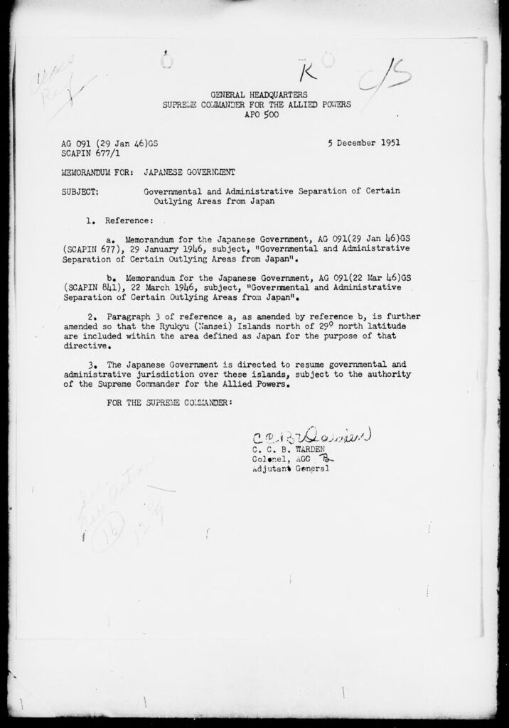
December 5, 1951 Supreme Commander for the Allied Powers Index No. 677/1 (SCAPIN-677/1)
On January 29, 1946, the Supreme Commander for the Allied Powers excluded Dokdo from the territory of Japan through SCAPIN-677. Later, in accordance with San Francisco Peace Treaty signed on September 2, 1951, the Supreme Commander for the Allied Powers issued SCAPIN-677/1 on December 5, 1951 to revise the scope of the territory of Japan.
However, there were no changes made regarding Dokdo, which had already been excluded from the territory of Japan. Therefore, both the San Francisco Peace Treaty and Supreme Commander for the Allied Powers indices can be seen as recognizing and reinforcing the sovereignty of Korea over Dokdo.
[original text]
1. Reference:
– a. Memorandum for the Japanese Government, AG 091(29 Jan 46)GS(SCAPIN 677), 29 January 1946, subject, “Governmental and Administraive Separation of Certain Outlying Areas from Japan”.
– b. Memorandum for the Japanese Government, AG 091(26 Mar 46)GS(SCAPIN 841), 26 March 1946, subject, “Governmental and Administraive Separation of Certain Outlying Areas from Japan”.
2. Paragraph 3 of reference a, as amended by reference b, is further amended so that the Ryukyu (Nansei) Islands north of 29° north latitude are included within the area defined as Japan for the purpose of that directive.
3. The Japanese Government is directed to resume governmental and administrative jurisdiction over these islands, subject to the authority of the Supreme Commander for the Allied Powers.
Supreme Commander for the Allied Powers Index No. 677/1
*source: NDL Digital Collections
January 18, 1952 Proclamation of Sovereignty over Adjacent Seas
During the Korean War, on January 18, 1952, the Korean government issued a formal proclamation through the State Council notice and publication in the official gazette, establishing a maritime sovereignty line known as the “Peace Line” (also called the Syngman Rhee Line). This line was set to protect the coastal waters of Korea, including Dokdo, asserting the sovereignty of Korea over these adjacent seas.
*source: National Archives of Korea
In response, Japan sent its Coast Guard patrol vessels or fishing boats to Dokdo, attacking residents there or making unauthorized landings. However, local residents from Ulleungdo, Dokdo Volunteer Forces, police and the navy worked together with the Korean government to repel and block these instructions.
After hearing news of Japan’s provocations, President Syngman Rhee issued a strong response. On July 18, 1952, he ordered that all foreign fishing boats operating within the Peace Line be seized. On October 4, 1952, he issued an Emergency Order establishing the “Decree on Seizure and Trial”, under which foreign ships that approached or attempted to land on Dokdo were to be captured and their crew arrested to be brought to trial.
Japan’s continued provocations and Korea’s firm responses continued until June 22, 1965, when Korea and Japan signed a fisheries agreement. By that time, the Korean Navy and Korea Coast Guard had seized 328 vessels and detained 3,929 Japanese crew members.
Notably, on April 13, 1956, during a session of the Judicial Affairs Committee of the House of Representatives of Japan, Mamoru Shigemitsu (重光葵), then Minister of State, gave a response that effectively acknowledged the validity of Korea’s Peace Line.
[translation]
○Minister of State Shigemitsu: Since the San Francisco Peace Treaty, Korea has been an independent nation. While there may be various international opinions and criticisms about how it exercises its sovereignty, I believe that is acceptable. However, Japan cannot deny that sovereignty.
[original text]
○重光国務大臣: サンフランシスコ平和条約以来韓国は独立国となっておる。それが独立国の主権を運用して、その運用の仕方の批評は国際的にいろいろあって差しつかえはないものとも思いますが、そのことについて日本がこれを否認していくということはできぬことであります。
Speaker No. 18 in the minutes of the 24th Session of Japan’s 24th National Diet, House of Representatives Legal Affairs Committee, Meeting No. 24 (24th National Diet, House of Representatives Legal Affairs Committee, No. 24, April 13, 1956)
*source: Minutes of the Diet Database System, National Diet Library
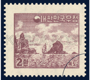
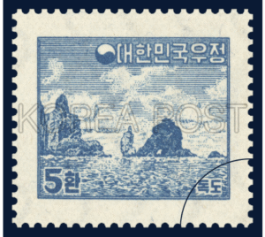
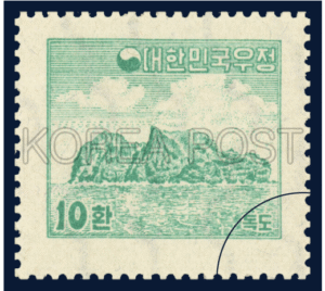
September 15, 1954 Ministry of Communications, Dokdo Stamp
On September 15, 1954, the Ministry of Communications (present-day Korea Post) issued three Dokdo-themed stamps to raise awareness of the image of Dokdo both at home and abroad.
Since then, stamps featuring Dokdo continued to be issued, including: Scenery of Dokdo (August 1, 2002), Natural environment of Dokdo (January 16, 2004), and Old maps depicting Dokdo (Feburary 28, 2007). Dokdo remains a recurring theme in customized stamps to this day.
three types of Dokdo stamps issued by the Ministry of Communications on September 15, 1954
*source: Korean Stamp Portal Service
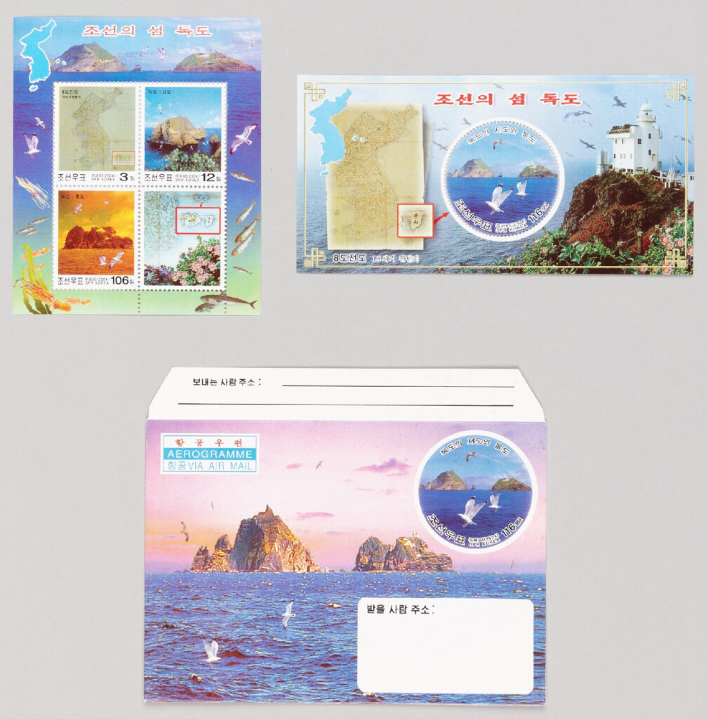
On April 18, 2004, North Korea also issued a Dokdo stamp, which was later made known in Korea.
*source: eMuseum, National Museum of Korea
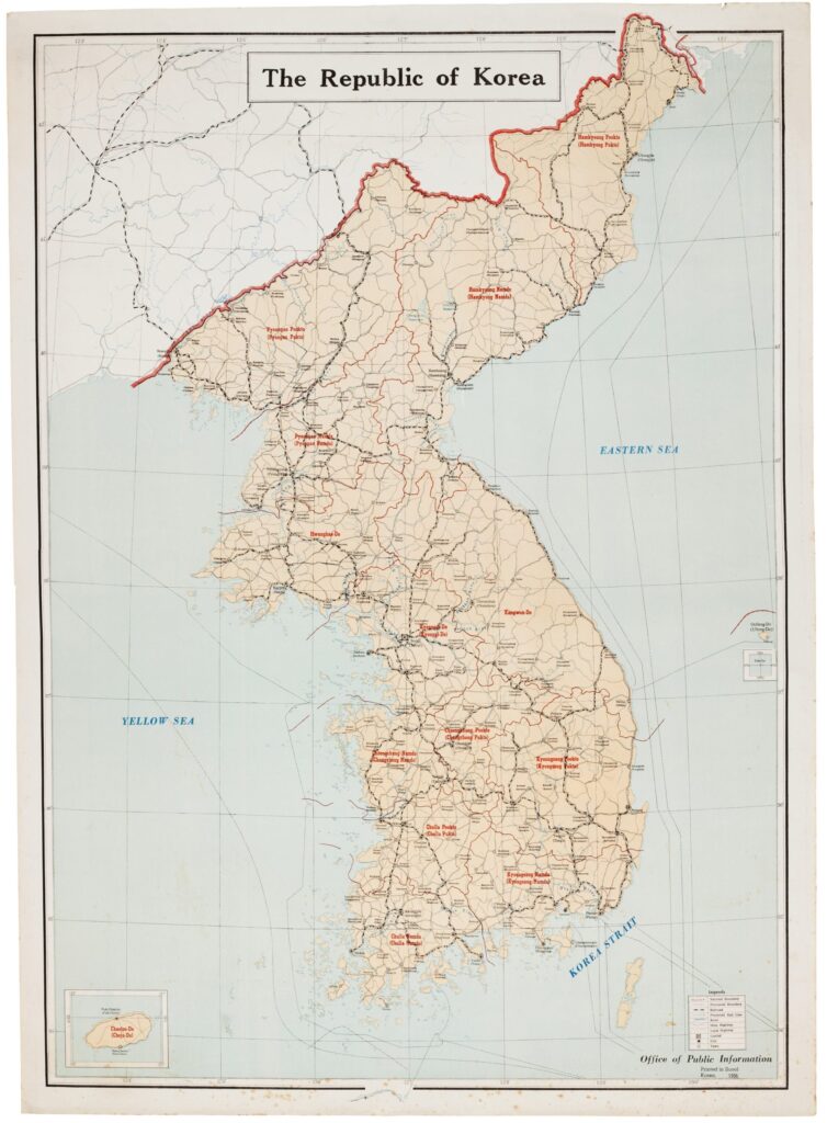
1956 Office of Public Information, The Republic of Korea
After Korea established the government of the Republic of Korea on August 15, 1948, following the end of Japanese imperial rule, the Korean War (June 25, 1950 – July 27, 1953) once again devastated the entire nation.
While recovering from the damage and rebuilding national strength, in 1956, the Office of Public Information (present-day Ministry of Culture, Sports and Tourism) created an English-language map titled The Republic of Korea, which included the English name for Dokdo (then written as Tok-do).
This map was distributed to foreign government agencies, libraries, and institutions to introduce Korea to the international community and promote awareness of Korean geography and place names.
*source: Northeast Asian History Network, Northeast Asian History Foundation
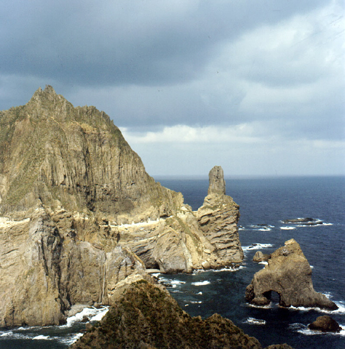
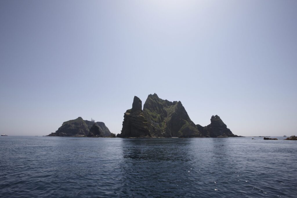
Dokdo since the 1960s
Dokdo has continued to be a precious part of the easternmost territory of Korea and is known as the island where the sun rises first. It has received much attention and love from the Korean people.
The number of visitors to Dokdo has been steadily increasing—from 41,134 in 2005 to 280,312 in 2022, with about 500 people visiting the island each day on average.
In order to preserve Dokdo in a peaceful and safe manner, the Korean government has designated it as ‘Natural Monument No. 336, Dokdo Island Natural Reserve’ under the Cultural Heritage Protection Act and as a ‘Natural Environment Conservation Area’ under the National Land Planning and Utilization Act.
The National Archives of Korea has released videos and photos showing Dokdo’s geography, ecosystem, history, security presence, and the activities of haenyeo (female divers) on the island. These materials are valuable records that give us a glimpse of Dokdo as it was around 50 years ago.
video footage of Dokdo filmed between 1971 and 1988
*source: National Archives of Korea
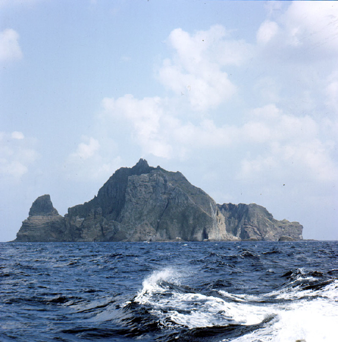
Dokdo filmed on September 29, 1976
*source: National Archives of Korea
Concluding “Dokdo in History”
So far, we have examined Dokdo through historical records.
In summary, since the year 512 when Silla incorporated Usan-guk, Korea has continuously recognized and managed Dokdo as an attached island of Ulleungdo and as Korean territory.
Except for Japan, which is making unfair unilateral claims, no country or international organization in the world denies Korea’s territorial sovereignty over Dokdo.
On the other hand, Japan never once claimed Dokdo as its territory until it illegally and unilaterally tried to incorporate Dokdo without Korea’s knowledge in 1905.
After 1945, the Allied Powers, who defined Japan’s territorial issues, excluded Dokdo from Japan’s territory. Japan also signed a treaty recognizing the validity of these Allied actions. Therefore, Japan’s claims over Dokdo go against historical truth and the understanding of the international community.
We hope Japan will quickly acknowledge the historical truth, withdraw its unfair claims to Dokdo, and become a more trusted country in the international community.