The Japanese government continues to make a unilateral and false claim that Dokdo, the inherent territory of Korea, belongs to Japan.
While it is clear that such a claim by Japan is unjust, the Japanese government continues to promote its stance not only domestically but also internationally through official publications such as the Diplomatic Bluebook by the Ministry of Foreign Affairs of Japan, the Defense of Japan by the Ministry of Defense of Japan. various pamphlets and exhibition materials. In particular, this misinformation is included in school textbooks, continuously implanting incorrect perceptions in the minds of Japanese students, which is a serious problem.
In this context, understanding the basis of Japan’s claim that Dokdo is their territory—and why that claim is wrong—is essential. It helps deepen our knowledge and understanding of Dokdo and enables us to effectively respond to questions by friends from other countries. This is a necessary part of informing the international community of the truth about Dokdo.
In Japan, various institutions—including government agencies and academic organizations—publish a considerable amount of material about Dokdo. Among them, the most well-known is the Ministry of Foreign Affairs of Japan’s <10 points to understand the Takeshima dispute>, which has been translated to 12 different languages for international distribution. Based on this publication, we will explain Japan’s claims and the problems with those claims.
Japan’s Claims and Problems
- Japan has long recognized the existence of “Dokdo”.
- There is no evidence indicating that the Republic of Korea has long recognized the existence of Dokdo.
- Japan had established sovereignty over Dokdo by the mid-17th century at the latest.
- While Japan prohibited the passage to Utsuryo Island towards the end of the 17th century, the lack of a prohibition on passage to Dokdo continued.
- The Republic of Korea currently refers to the false statement made by Ahn Yong-bok as one of the foundations for its claim to sovereignty over Dokdo.
- In 1905, Japan reaffirmed its sovereignty over Dokdo through a Cabinet decision.
- In the process of drafting the San Francisco Peace Treaty, the Republic of Korea requested that the United States add Dokdo to the territories to be renounced by Japan.
However, the United States rejected that request. - Dokdo was designated as a bombing range for the U.S. Forces in Japan.
- The Republic of Korea delineated the so-called “Syngman Rhee Line” on the high seas in contravention of international law, and illegally occupied Dokdo as a unilateral act.
- Japan has been repeatedly proposing to the Republic of Korea that the dispute over the sovereignty of Dokdo should be referred to the International Court of Justice (ICJ). However, the Republic of Korea is refusing these proposals.
Japan’s Claim 1: Japan has long recognized the existence of “Dokdo”
Japan claims that it has recognized Dokdo as Japanese territory since ancient times, citing the 1846 edition of the Revised Complete Map of Japanese Lands and Roads (改正日本輿地路程全圖).
▶ TRUTH: Japan historically recognized Dokdo as a part of Ulleungdo, which is Korean territory!
The original edition of this map, first created in 1779 by Nagakubo Sekisui (長久保赤水), clearly shows Dokdo drawn outside of Japan’s longitude and latitude lines, along with Ulleungdo and the Busan area. Unlike the territory of Japan, which is colored on the map, Dokdo is not colored—indicating that Japan did not consider Dokdo part of its territory at the time.
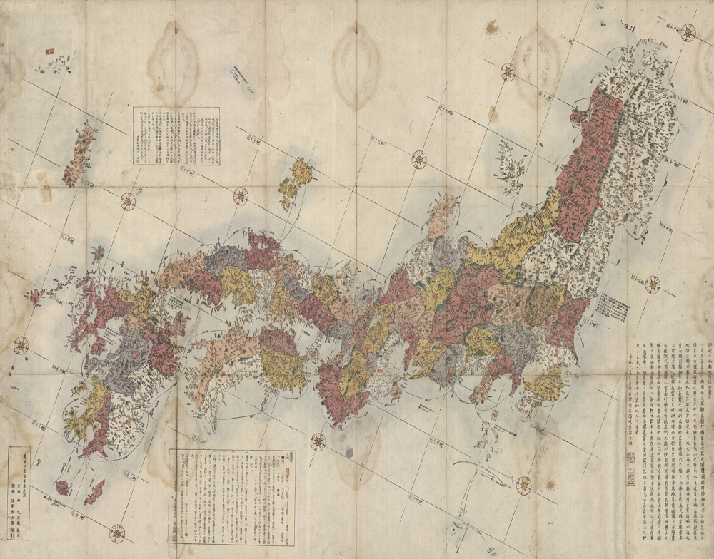
Revised Complete Map of Japanese Lands and Roads (1791 edition)
with a close-up of the Ulleungdo and Dokdo section.
Unlike the Japanese territories marked on the map,
Ulleungdo and Dokdo are located outside the lines of latitude and longitude and are not colored in.
At the time, Japan referred to Dokdo as Matsushima (松嶋) and Ulleungdo as Takeshima (竹嶋).
*source: Dokdo, Ministry of Foreign Affairs, Republic of Korea
Before the Revised Complete Map of Japanese Lands and Roads was created, in the 1600s, the Oya family from Japan, which secretly fished near Ulleungdo without the knowledge of the Joseon government, recorded Dokdo as an island that belongs to Ulleungdo.
[translation]
Matsushima (Dokdo) within the confines of Takeshima (Ulleungdo)
[original text]
竹嶋之內松嶋
Records of the Oya Family (大谷家文書)
* At the time, Japan referred to Dokdo as Matsushima (Songdo / 松嶋 or 松島) and Ulleungdo as Takeshima (Jukdo / 竹嶋 or 竹島).
Saito Hosen (齋藤豊仙), an official from the Izumo region (出雲), left behind a record called Records on Observations in Oki Province (隱洲視聽合記) after seeing Dokdo and Ulleungdo while drifting in the East Sea. In it, he defined the northwestern boundary of Japan as the present-day Oki Islands.
[translation]
The two islands [Ulleungdo and Dokdo], which are uninhabited, are located towards Goryeo [Korea] in the same way that Unshu [eastern part of today’s Shimane prefecture] is located towards Inshu [Oki Islands].
Therefore, Inshu [Oki Islands] shall mark Japan’s northwesternmost boundary.
[original text]
此二島 無人之地 見高麗 如自雲州
望隱州 然則日本之乾地 以此州爲限矣
Records on Observations in Oki Province (隱洲視聽合記)
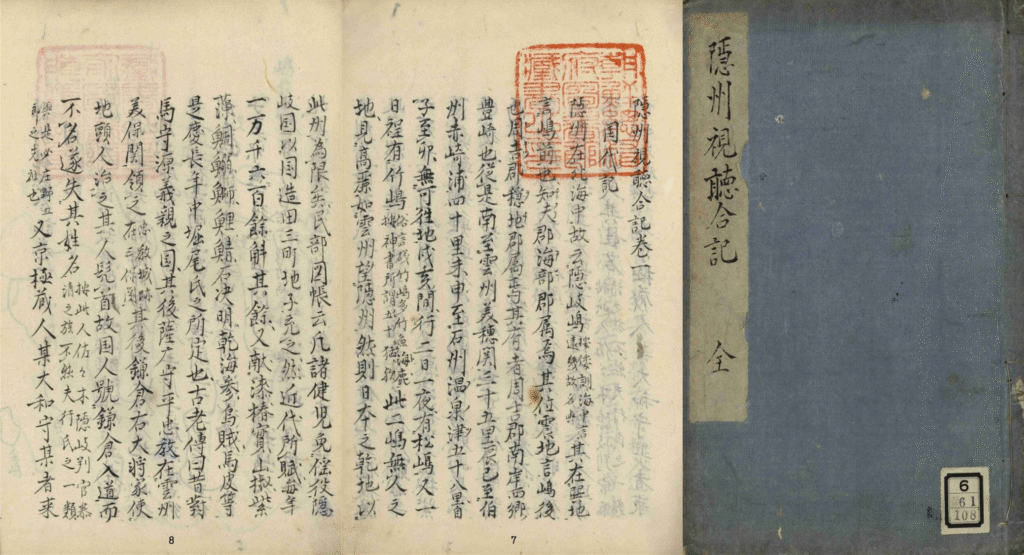
which includes a description of Japan’s northwestern boundary (Oki Island)
*source: Records of Observations in Oki Province, National Library of Korea
After that, in 1875 and 1876, the Japanese Navy created a map of the eastern coast of Korea that included Dokdo (East Coast of Korea, 朝鮮東海岸圖). In 1877, the Japanese Army produced a map of Japan that excluded Dokdo (Complete Map of Japan, 大日本全圖).
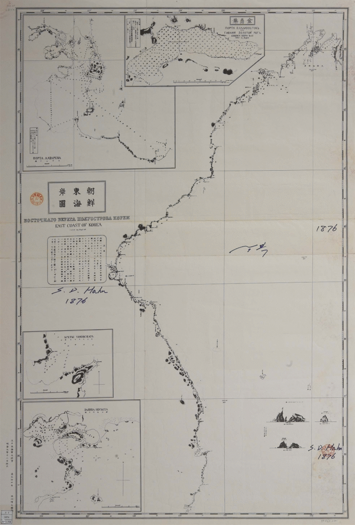
*source: Digital Library, National Assembly Library
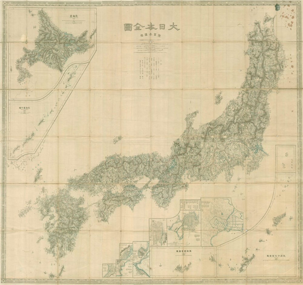
*source: Dokdo, Ministry of Foreign Affairs, Republic of Korea
Most decisively, in 1877, the Dajokan, which was the highest administrative body of Japan at the time, responded to an inquiry from the Ministry of Home Affairs about whether Ulleungdo and Dokdo should be included in Shimane Prefecture. The Dajokan issued a directive stating, “Regarding Ulleungdo and the other island (Dokdo), keep in mind that Japan has nothing to do with them,” clearly excluding Dokdo from Japanese territory.
[translation]
March 20, 10th year of Meiji
[The Ministry of Home Affairs], having claimed that it has been informed hat Japan has nothing to do with these islands, through diplomatic correspondences between the old government (Edo Shogunate) and Joseon ever since people of Joseon set foot on the island in the fifth year of the Genroku (1692), to address your inquiry we propose to issue the following
There is one more island, called Matsushima (Dokdo)
[original text]
明治十年三月廿日
別紙内務省伺日本海内竹嶋外一嶋地籍編纂之件
右ハ元禄五年朝鮮人入嶋以来旧政府該国ト往復之末遂ニ本邦関係無之相聞候段申立候上ハ伺之趣御聞置左之通御指令相成可然哉此段相伺候也
次ニ一島アリ松島ト呼フ
On March 17, 1877, Japan’s Ministry of Home Affairs inquired with the higher authority, the Dajokan, about the jurisdiction over Ulleungdo and Dokdo
* At the time, Japan referred to Dokdo as Matsushima (Songdo / 松嶋 or 松島) and Ulleungdo as Takeshima (Jukdo / 竹嶋 or 竹島).
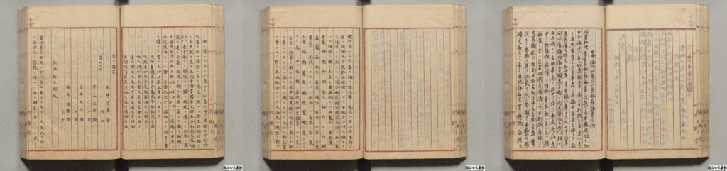
main text of the official document submitted in 1877 by
Japan’s Ministry of Home Affairs to inquire about the jurisdiction of Dokdo
*source: Digital Archive, National Archives of Japan
[translation]
Directive
Regarding Takeshima [Ulleungdo] and one other island [Dokdo] about which an inquiry was submitted, bear in mind that our country [Japan] has nothing to do with them.
[original text]
御指令按
伺之趣竹島外一嶋之義本邦関係無之義ト可相心得事
On March 29, 1877, Japan’s Dajōkan (Grand Council of State) issued a directive to the Ministry of Home Affairs stating that Ulleungdo and Dokdo have no relation to Japan
As shown, numerous historical records—including official Japanese government documents, maps, and civilian writings—clearly demonstrate that Japan recognized Dokdo not as its own territory, but as an island that belongs to Ulleungdo and a part of Korean territory.
Japan’s Claim 2: There is no evidence indicating that the Republic of Korea has long recognized the existence of Dokdo
Japan claims the name “Usando” refers not to Dokdo but to Ulleungdo, or even to a non-existent island, arguing that Korea did not historically recognize Dokdo as part of its territory.
▶ TRUTH: Japan historically recognized Dokdo as a part of Ulleungdo, which is Korean territory!
Korea has long recognized Dokdo as a part of its territory and an island that belongs to Ulluengdo, visible from Ulleungdo itself. Numerous historical records from both Korea and Japan comfirm that the island referred to as Usando is in fact-present day Dokdo. These include Korean sources such as Sejong Sillok Jiriji (Geographical Records in the Annals of King Sejong, 世宗實錄地理志), Sinjeung Dongguk Yeoji Seungram (Revised and Augmented Edition of the Survey of the Geography of Korea, 新增東國輿地勝覽), Mangi Yoram (Manual of State Affairs for the Monarch, 萬機要覽), Jeungbo Munheon Bigo (Revised and Augmented Reference Compilation of Documents on Korea, 增補文獻備考), as well as Japanese sources like Inbanji 因幡誌 (1795) and History of Modernization of Joseon 朝鮮開化史 (1901).
[translation]
The two islands of Usan [Dokdo] and Murueng [Ulleungdo] are located in the middle of the sea due east of the hyeon [Uljin county].
The two islands are not far apart from each other and are visible on a clear day. They were called Usan-guk or Ulleungdo during the Silla period.
[original text]
于山武陵二島 在縣正東海中。
二島相距不遠 風日淸明 則可望見。
新羅時, 稱于山國, 一云鬱陵島。
Sejong Sillok, Volume 153, Jiriji – Uljin-hyeon, Samcheok Protectorate, Gangwon-do
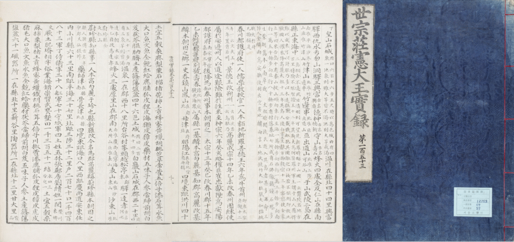
*source: The Veritable Records of the Joseon Dynasty, National Institute of Korean History
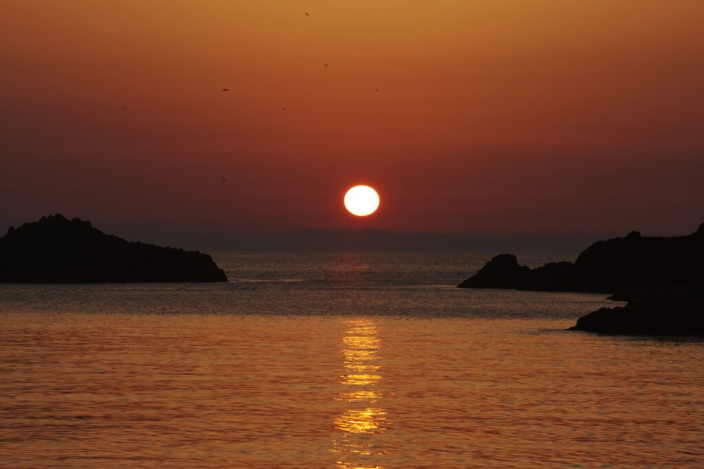
And as just recorded in Sejong Sillok Jiriji, it is still possible to see Ulleungdo and Dokdo from each other on clear days today.
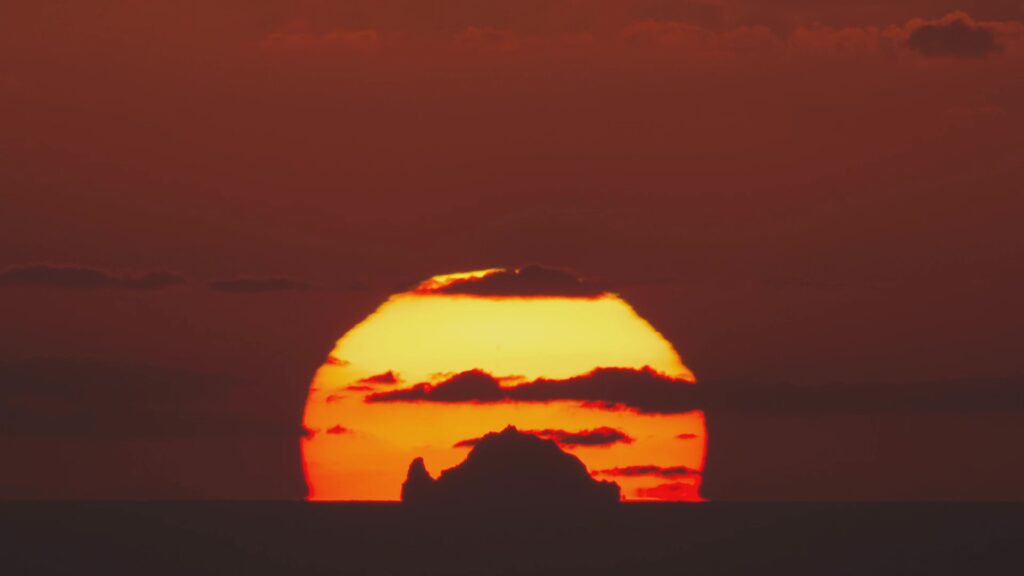
(left) Dokdo seen from Ulleungdo
*source: Ministry of Foreign Affairs, Republic of Korea YouTube ‘Dokdo sunset from Ulleungdo’
(shot by Kwon O-chul)
(right) Ulleungdo seen from Dokdo
*source: Ministry of Foreign Affairs, Republic of Korea YouTube
Just as recorded in Sejong Sillok Jiriji, it is possible to see Dokdo from Ulleungdo on a clear day. In the past, when there was no pollution or fine dust and the air was clearer, it was likely to be more visible than it is now.
The Dongguk Munheon Bigo (東國文獻備考), published in 1770, clearly records Usando as belonging to Usan-guk and includes the name Matsushima (松島, the name used by Japan for Dokdo at the time), clearly marking Dokdo as Joseon territory.
[translation]
Ulleung and Usan (Dokdo) are part of the territory of Usan state, and Usan (Dokdo) is written as Matsushima by the Japanese people.
[original text]
于山島 鬱陵島… 二島一卽于山…
鬱陵于山皆于山國地 于山則倭所謂松島也
Dongguk Munheon Bigo, Volume 9
* At the time, Japan referred to Dokdo as Matsushima (Songdo / 松嶋 or 松島).
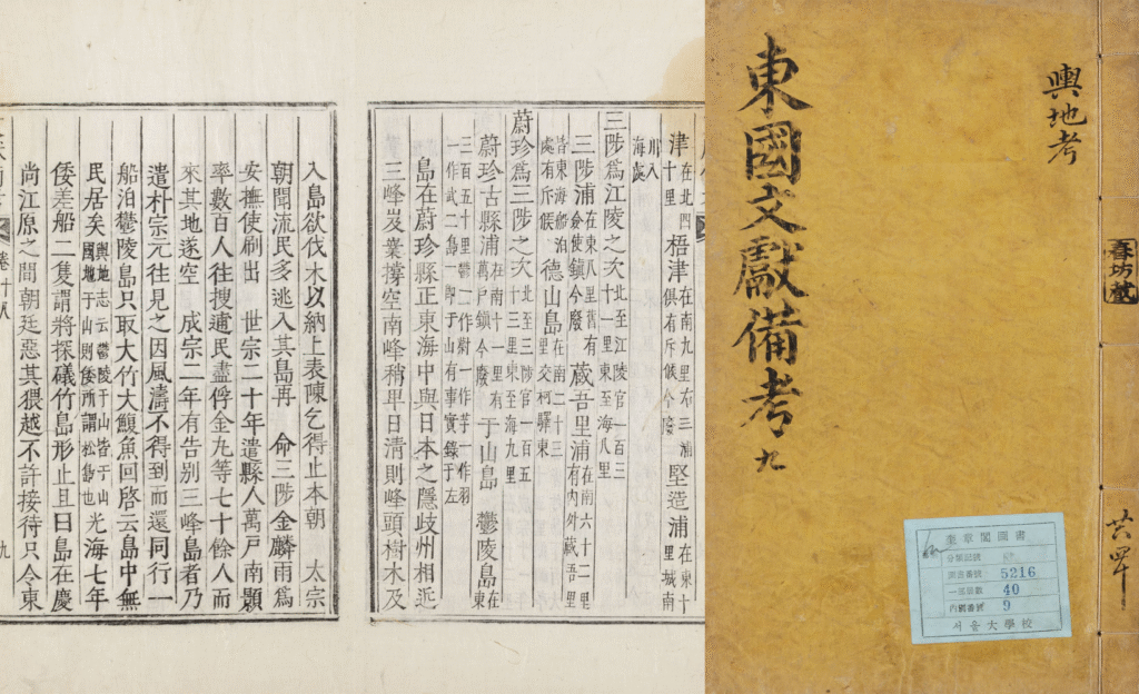
which includes a description of Usan-guk and Usan-do (Dokdo)
*source: Kyujanggak Institute for Korean Studies, Seoul National University
The Mangi Yoram (萬機要覽) in 1808, the Jeungbo Munheon Bigo (增補文獻備考) in 1908, along with other later official Joseon documents, contain the same information. Like this, in the past, Korea referred to Dokdo as Usando and recorded it as an island that belongs to Ulleungdo, visible from Ulleungdo itself. This is also confirmed in Japanese literature.
The Inbanji (因幡誌), published in 1795, is a geographical book about the Tottori region compiled by Abe Kyoan (安部恭庵), a physician from Tottori-han, Japan. This book explains the meaning of “Joseon’s Two Islands, Ulleung and Usan (朝鬱兩島)”, which was written on the flag used by Ahn Yong-bok during his second landing in Japan in 1696. It clarifies that Usando (子山嶋) of Joseon was referred to Matsushima (松嶋), which was the name Japan used for Dokdo at the time.
During his second landing in Japan in 1696, Ahn Yong-bok reportedly sailed with a flag on his boat that read 朝鬱兩島監稅將臣安同知騎, meaning he was an official in charge of collecting taxes and managing the two islands for Joseon.
[translation]
Ulleung and Usan are Ulleungdo (Takeshima in Japan), Usando (Usan Island, Matsushima in Japan).
[original text]
朝欝両島ハ 欝陵嶋(日本ニテ是ヲ竹嶋ト称ス) 于山嶋(ウサンスム 日本ニテ松嶋ト呼)是ナリ。
Inbanji
* At the time, Japan referred to Dokdo as Matsushima (松嶋 or 松島).
In addition, records from later Japanese publications—such as The History of Modernization of Joseon (朝鮮開化史) published in 1901—continue to show Usando as a part of Ulleungdo and Joseon territory.
The History of Modernization of Joseon (朝鮮開化史) was written by a Japanese person named Tsuneya Seifuku (恒屋盛服), who stayed in Korea and served as an advisor to the Government Gazette Bureau, established under the Uijeongbu (State Council), in June 1894 during the Gabo Reform. In this book, he refers to Usando as an island that belongs to Ulleungdo and introduces it as Matsushima (松島), the name Japan used for Dokdo at the time.
[translation]
Ulleungdo (omitted)
There are six large and small islands, among which the well-known ones are Usando (called Matsushima by the Japanese) and Takeshima.
[original text]
欝陵島 (중략)
大小六島アリ 其中著名ナルヲ 于山島 (日本人ハ松島ト名ク) 竹島ト云
main text of the section on Ulleungdo in The History of Modernization of Joseon
* At the time, Japan called Dokdo Matsushima (Songdo / 松嶋 or 松島), Yanko Island (ヤンコ島), Liancourt Rocks (リアンクルド岩), and so on.
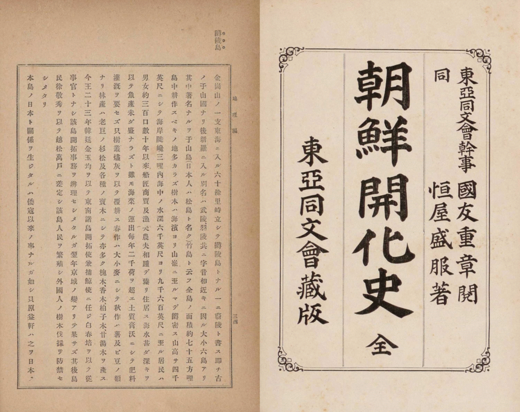
*source: National Library of Korea
As shown, both Korean and Japanese sources confirm that Usando is present-day Dokdo.
These records also show that even in Japan, Dokdo was consistently recognized as Korean territory and as an island that belongs to Ulleungdo.
Japan’s Claim 3: Japan had established sovereignty over Dokdo by the mid-17th century at the latest
Japan claims that in 1618, the Edo Shogunate granted sea passage permits (渡海免許) to Oya Jinkichi (大谷 甚吉) and Murakawa Ichibe (村川 市兵衛) from Tottori-han (鳥取藩), Japan, and that the Oya (大谷) and Murakawa (村川) families used Dokdo as a stopover and fishing ground on their way to Ulleungdo. Based on this, Japan argues that it established sovereignty over Dokdo in the mid-17th century.
▶ TRUTH: Japan recognized Dokdo as an island of Ulleungdo and as Korean territory not only in the mid-17th century but also in the years that followed!
Regardless of the fact that some Japanese people fished around Dokdo at the time, the actions by the central and local governments of Japan, along with later historical records, clearly show that Japan did not recognize Dokdo as its territory.
As explained in the rebuttal for the first claim, the Oya (大谷) family—who fished around Ulleungdo in the 1600s—recognized Dokdo as an island that belongs to Ulleungdo. In 1667, a Japanese local official named Saito Hosen (齋藤豊仙) defined the northwestern boundary of Japan as present-day Oki Islands.
Later, in 1693, the Ahn Yong-bok incident sparked a territorial dispute between Joseon and Japan over Ulleungdo. In 1695, the Edo Shogunate asked Tottori-han, to which the Japanese fishermen involved belonged, whether Ulleungdo belonged to Tottori-han and if any other islands besides Ulleungdo were under its jurisdiction. Tottori-han replied that neither Ulleungdo nor Dokdo belonged to it.
[translation]
1. Since when has Takeshima [Ulleungdo], which belongs to Inshu and Hakushu [Inaba and Hoki: today’s Tottori prefecture], been under the jurisdiction of the two states [Inaba and Hoki]?
1. Apart from Takeshima [Ulleungdo], are there any other islands that belong to the two states [Inaba and Hoki]?
[original text]
一. 竹島は因幡伯耆附属にては無御座候…
一. 竹島松島其外両国江附属の島無御座候事
Tottori-han’s Submission
* At the time, Japan referred to Dokdo as Matsushima (Songdo / 松嶋 or 松島) and Ulleungdo as Takeshima (Jukdo / 竹嶋 or 竹島).
After receiving this response, the Edo Shogunate issued a ban on sea passage to the Ulleungdo area on January 28, 1696. As a result, Japanese access to Ulleungdo and Dokdo for fishing or any other activity came to a stop.
Later, between 1833 and 1836, a Japanese person named Aizuya Hachiemon (會津屋八右衛門) was caught by Japanese inspectors for engaging in illegal trade around Ulleungdo and Dokdo without permission from the Edo Shogunate. He was executed in 1836 for going overseas without authorization. During the investigation, Hachiemon submitted a hand-drawn map called Jukdo Banggakdo (竹島方角圖), in which the territory of Japan such as Oki Island was marked in yellow, while Ulleungdo (竹嶋) and Dokdo (松嶋) were marked in red—just like mainland Joseon.
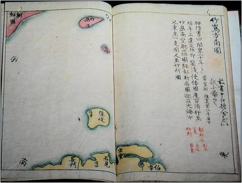
*source: Dokdo Research Series 21, Dokdo Institute, Yeungnam University
In 1870, officials from the Ministry of Foreign Affairs of Japan conducted a detailed investigation of Joseon’s diplomatic, military, trade, and port affairs and compiled a report entitled Confidential Inquiry into the Particulars of Relations with Joseon (朝鮮國交際始末內探書). Under the title “The background to how Ulleungdo and Dokdo became annexed to Joseon”, the report clearly records Ulleungdo and Dokdo as Joseon territory, further demonstrating that Japan continued to recognize Dokdo as part of Joseon territory.
[translation]
The background to how Takeshima (Ulleungdo) and Matsushima (Dokdo) became annexed to Joseon
Matsushima [Dokdo] is an island next to Takeshima [Ulleungdo]. No records regarding Matsushima exist, but letters exchanged in the late seventeenth century include comments relating to Takeshima [Ulleungdo]. For some time since the late seventeenth century, Joseon had sent people to reside in Takeshima [Ulleungdo], but now it has become an uninhabited island again. It is heard that bamboo, reeds that are thicker than bamboo, and ginseng grow there. Fish may be caught, too. This record is based upon our local investigation. We will report this together with our investigation documents, illustrations, and maps by topic after returning to Japan.
The diplomatic mission of Sada Hakubo, Moriyama Shigeru, and Saito Sakai in April, 1870
[original text]
一. 竹島松島朝鮮附屬ニ相成候始末
此儀松島ハ竹島ノ隣島ニチ松島ノ儀ニ付是迄揭載セシ書留モ無之. 竹島ノ儀ニ付テハ元祿度後ハ暫クノ間朝鮮ヨリ居留ノ爲差遣シ置候處當時ハ以前ノ如ク無人ト相成竹木又ハ竹ヨリ太キ葭ヲ産シ人參等自然ニ生シ其餘漁産モ相應ニ有之趣相聞ヘ候事.
右ハ朝鮮事情實地偵索イタシ候大略書面ノ通リニ御座候間一ト先歸府仕候依之件々取調書類繪圖面トモ相添此段申上候以上.
午 四月 外務省出仕 佐田白茅 森山茂 齎藤榮
Confidential Inquiry into the Particulars of Relations with Joseon
* At the time, Japan referred to Dokdo as Matsushima (Songdo / 松嶋 or 松島) and Ulleungdo as Takeshima (Jukdo / 竹嶋 or 竹島).
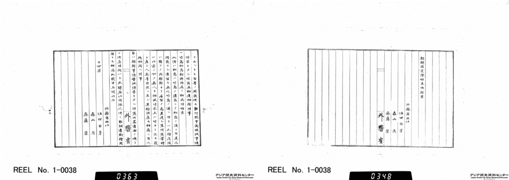
focusing on the sections about Ulleungdo and Dokdo
*source: Japan Center for Asian Historical Records, National Archives of Japan
“1. 1870(1)/Vol. 4/1 From 28 January, 1870 to April, 1870”
Japan Center for Asian Historical Records (JACAR) Ref.B03030163900, Collection of the documents relevant to the policy towards Korea/Management paper for the Korean issues Vol. 2 (1-1-2-3_13_002) (Diplomatic Archives of the Ministry of Foreign Affairs)
In addition, as explained in the first claim, the East Coast of Korea (朝鮮東海岸圖) in 1875 and 1876 (included Dokdo in the map of Korea), Complete Map of Japan (大日本全圖) in 1877 (excluded Dokdo from the map of Japan), the Dajokan Order (太政官指令) of 1877 (“bear in mind that Dokdo has nothing to do with Japan”) all show that even during the 17th century—when Japan claimed to have established sovereignty over Dokdo—and afterward, Japan actually recognized that Dokdo was not part of its territory.
Japan’s Claim 4: While Japan prohibited the passage to Utsuryo Island towards the end of the 17th century, the lack of a prohibition on passage to Dokdo continued
Japan claims that although the Edo Shogunate in 1696 banned sea passage to Ulleungdo after recognizing it as Joseon territory, it still considered Dokdo to be Japanese territory and thus did not ban sea passage to Dokdo.
▶ TRUTH: The 1696 sea passage ban to Ulleungdo issued by the Edo Shogunate also included a ban on sea passage to Dokdo!
Records from around the time of the 1696 sea passage ban clearly show that the ban included sea passage to Dokdo. This is because the Oya and Murakawa families from Japan had been fishing around Ulleungdo and its nearby island Dokdo based on a sea passage permit issued by the Edo Shogunate in 1625. After the 1696 ban on sea passage to Ulleungdo, fishing was also stopped not only at Ulleungdo but also at its nearby island, Dokdo.
In fact, the Edo Shogunate had never issued a separate sea passage permit for Dokdo apart from Ulleungdo. And when the sea passage ban was issued in 1696, no new permit was issued specifically for Dokdo either.
As explained in Japan’s claims 1 and 3, the Oya family from Tottori-han, who fished in the Ulleungdo area, recognized Dokdo as a part of Ulleungdo.
Also, after the 1696 ban made fishing impossible, descendants of the Oya and Murakawa families who faced financial hardship submitted a petition to the Shogunate asking for permission to fish again around Ulleungdo. In that petition, they explicitly mentioned that “sea passage to Ulleungdo and Dokdo was banned”, which confirms that the sea passage ban to Ulleungdo obviously included Dokdo as well.
[translation]
After the sea passage for the two islands of Takeshima [Ulleungdo] and Matsushima [Dokdo] have been banned,
[original text]
竹嶋松島兩嶋渡海禁制二被爲仰付候以後八、
Petition submitted by Oya Katsufusa on April 18, 1740.
* At the time, Japan referred to Dokdo as Matsushima (Songdo / 松嶋 or 松島) and Ulleungdo as Takeshima (Jukdo / 竹嶋 or 竹島).
As explained in Japan’s claims 1 through 3, the continued recognition that Japanese sea passage was banned not only to Ulleungdo but also to Dokdo can be confirmed through various official Japanese documents and maps that either excluded Dokdo from Japanese territory or included it as part of Joseon territory. This includes the Jukdo Banggakdo drawn by the Japanese person Aizuya Hachiemon during an investigation. He was executed in 1836 for engaging in illegal trade around Ulleungdo and Dokdo.
Japan’s Claim 5: The Republic of Korea currently refers to the false statement made by Ahn Yong-bok as one of the foundations for its claim to sovereignty over Dokdo
Japan claims that the testimony of Ahn Yong-bok, which Korea cites as evidence for its sovereignty over Dokdo, lacks credibility because many of his statements do not align with Japanese records or contain content not found in them.
▶ TRUTH: Ahn Yong-bok’s activities are supported by historical records from both Korea and Japan!
It is possible to confirm through Korean and Japanese historical sources that Ahn Yong-bok traveled to Japan and clearly asserted that not only Ulleungdo but also Dokdo belonged to Joseon.
Although there are differences between Korean and Japanese records regarding his testimony and actions, his landings in Japan in 1693 and 1696 prompted the Japanese government in 1696 to ban Japanese sea passage to the Ulleungdo region. Numerous Japanese official documents and maps afterward show that Japan did not treat Dokdo as its own territory.
In particular, during Ahn Yong-bok’s second landing in Japan in 1696, Japanese officials Nakase Tanuemon (中瀨彈右衛門) and Yamamoto Seiemon (山本淸右衛門), under orders from the Edo Shogunate, investigated Ahn on Oki Island from May 20 to 22, 1696. The report they compiled on May 23, 1696, titled Memorandum on the Arrival of a Vessel from Joseon in 1696 (元祿九丙子年 朝鮮舟着岸 一卷之覺書), recorded the map Ahn presented, a document he received from Japan in 1693, and his testimony. Based on this evidence, the report confirmed that Ulleungdo and Dokdo were part of Gangwon Province in Joseon, supporting the claims found in Sukjong Sillok (Annals of King Sukjong).
[translation]
Takeshima (Ulleungdo) and Matsushima (Dokdo) belong to Gangwon province.
[original text]
江原道
此道ノ中ニ竹嶋·松嶋有之
Memorandum on the Arrival of a Vessel from Joseon in 1696
* At the time, Japan called Dokdo Matsushima (Songdo / 松嶋 or 松島) and Ulleungdo Takeshima (Jukdo / 竹嶋 or 竹島).
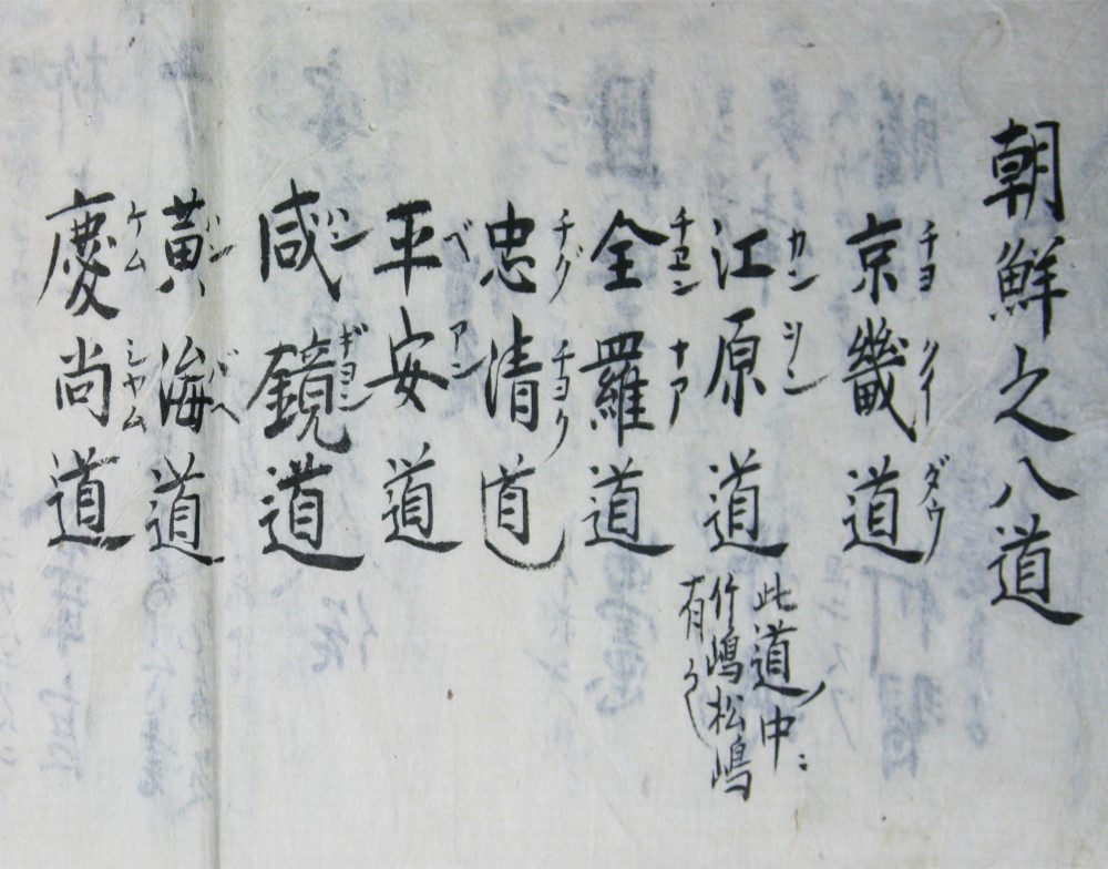
which describes the Eight Provinces of Joseon
*source: Dokdo, Ministry of Foreign Affairs, Republic of Korea
Therefore, Japan’s claim that Ahn Yong-bok’s testimony is false simply because of some discrepancies in historical records is not valid.
On the contrary, as described in Sukjong Sillok (Annals of King Sukjong), Ahn’s actions served as a key turning point that led Japan to recognize Dokdo and Ulleungdo as territory that belong to Joseon.
Japan’s Claim 6: In 1905, Japan reaffirmed its sovereignty over Dokdo through a Cabinet decision
Japan claims that in September 1904, Nakai Yozaburo (中井養三郎), a resident of Oki Island in Shimane Prefecture, petitioned for the incorporation of Dokdo and its lease for ten years, and in response, the Japanese government reaffirmed its claim by placing Dokdo under the jurisdiction of the Oki Island governor (島司) in January 1905. Japan also argues that Seokdo (石島), listed in the Korean Empire (Daehan Jeguk) Imperial Decree of 1900 under the jurisdiction of Ulleung County (now Ulleung-gun), does not refer to Dokdo and that Korea’s sovereignty over the island was not established.
▶ TRUTH: Japan’s actions were nothing more than an illegal, unilateral attempt to incorporate Korean territory!
As explained in Japan’s claims 2, 3 and 5, Dokdo had already been Korean territory since the year 512, a fact supported by numerous historical records from both Korea and Japan.
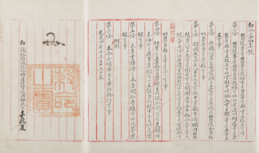
In particular, on October 25, 1900, the Korean Empire (Daehan Jeguk) issued an imperial decree to strengthen administrative control over Ulleungdo and its surrounding areas. This decree renamed Ulleungdo—then part of Uljin-hyeon in Gangwon Province—as Ulleung County (Uldo-gun) and explicitly placed Dokdo, which was considered an island that is a part of Ulleungdo, under the jurisdiction of Ulleung County. The decree was officially promulgated on October 27, 1900.
[translation]
The Renaming of Ulleungdo to Uldo and the promotion of the post of inspector [dogam] to county magistrate [gunsu]
Article 1. Ulleungdo shall be renamed Uldo and shall fall under the jurisdiction of Gangwon-do [Gangwon Province]
The post of inspector [dogam] shall be promoted to county magistrate [gunsu] and incorporated into officialdom, and the county shall be a class 5 county
Article 2. The county office shall be located in Taehadong, and as regards its districts, all of Ulleungdo as well as Jukdo and Seokdo [Dokdo] shall be placed under the jurisdiction of Uldo-gun (Uldo county).
[original text]
鬱陵島를 鬱島로 改稱ᄒᆞ고 島監을 郡守로 改正件
第一條 鬱陵島를 爵島라 改稱ᄒᆞ야 江原道에 附屬ᄒᆞ고 島監을 郡守로 改正ᄒᆞ야 官制中에 編入ᄒᆞ고 郡等은五等으로ᄒᆞㄹ 事
第二條 郡廳位置 台霞洞으로 定ᄒᆞ고 區域은 鬱陵全島와 竹島石島 管轄ᄒᆞㄹ 事
Imperial Decree No. 41
* Due to input issues with old Korean script, some characters are being displayed as “”.
*source: Kyujanggak Institute for Korean Studies, Seoul National University
The fact that Seokdo (石島), designated in Imperial Decree No. 41 of the Korean Empire as being under the jurisdiction of Ulleung County, refers to present-day Dokdo can be confirmed through the names used by local residents at the time, as well as dictionaries, Japanese survey records, and media.
In the Imperial Decree No. 41, Seokdo (石島) was the written form in Chinese characters of what local residents around Ulleungdo used to call Dol-seom (Stone Island)—which referred to Dokdo. Similarly, Jukdo (竹島, now an island on the northeast of Ulleungdo), another island placed under the jurisdiction of the Ulleung County governor along with Dokdo, was what residents called Daenamu-seom or Daet-seom (both meaning Bamboo Island), and was written in Chinese characters as 竹島.
Even in Joseon Jiji Jaryo (朝鮮地誌資料), published in 1911 by Japan’s Provisional Land Survey Bureau under the Japanese Government-General of Korea, there are examples where the Chinese character 石 was read as Dok in Korean, further supporting this interpretation.
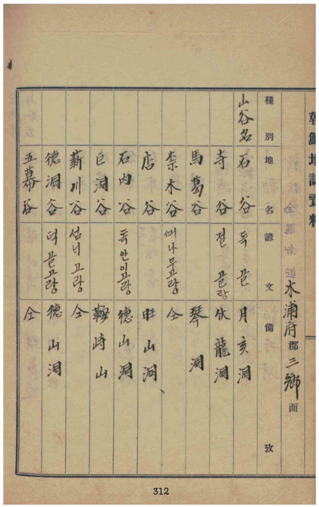
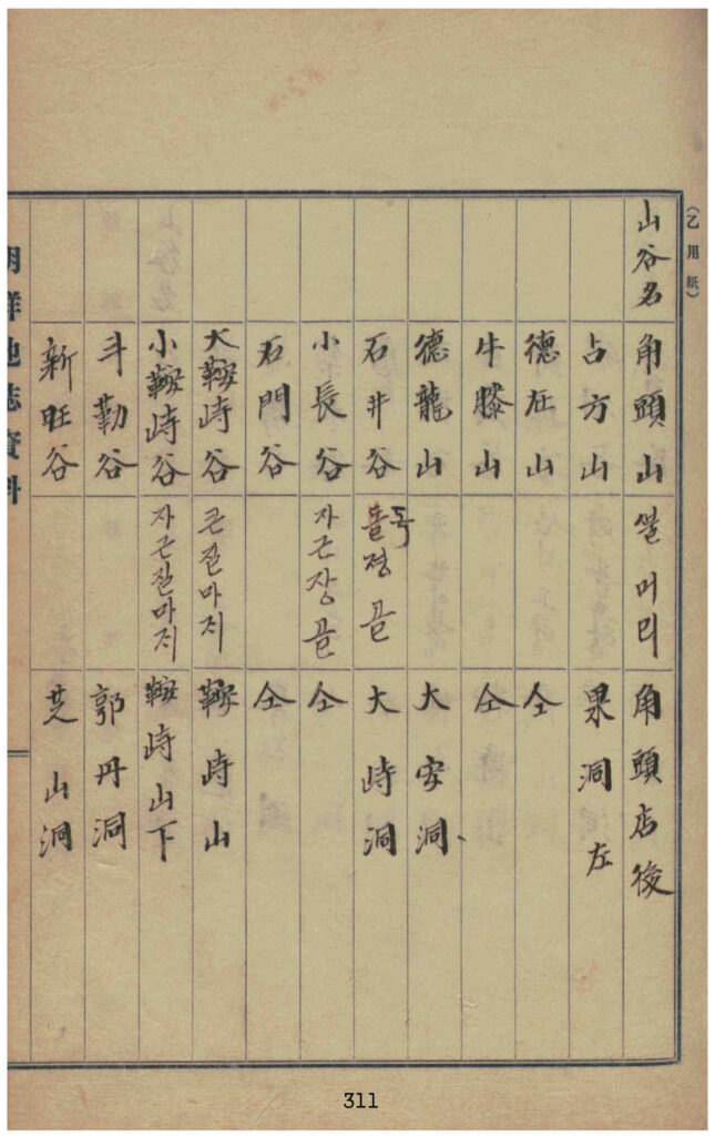
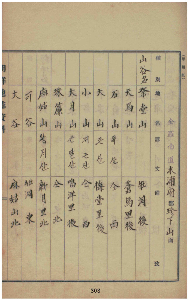
Examples of place names where the Chinese character ‘石’ (meaning “stone”) is
written as ‘독’ in Korean, such as 石山 (Doksan), 石谷 (Dokgol), and 石島 (Dokdo).
Quoted from Joseon Jiji Jaryo, Jeollanam-do Volume 3-1 (Volume 6), Mokpojugun (木浦廚郡)
*source: National Library of Korea
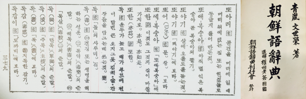
In the Korean Language Dictionary (朝鮮語辭典) written by Moon Se-young (文世榮), who served as a Standard Language Review Committee member in 1935 and a Revision Committee member in 1936 for the Korean Language Association, and published by the Korean Dictionary Publication Committee on July 10, 1938, the Korean word dok is defined as a dialect form of dol (stone); 石. This confirms the linguistic basis that the Korean name Dokdo corresponds to the Chinese characters Seokdo (石島).
*source: National Library of Korea
An article published on June 13, 1948, criticizing Japan’s illegal fishing and other provocations around Dokdo, titled Dokdo is Our Island – Its Original Name is Dolseom (石島), also confirms that the current name Dokdo originates from Dolseom (Stone Island), written in Chinese characters as 石島.
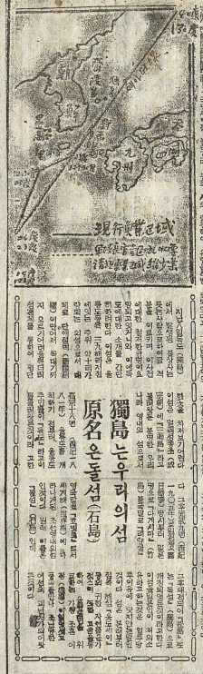
Hanseong Ilbo “Dokdo is our island, original name is Dolseom”
*source: Korea Newspaper Archive, National Library of Korea
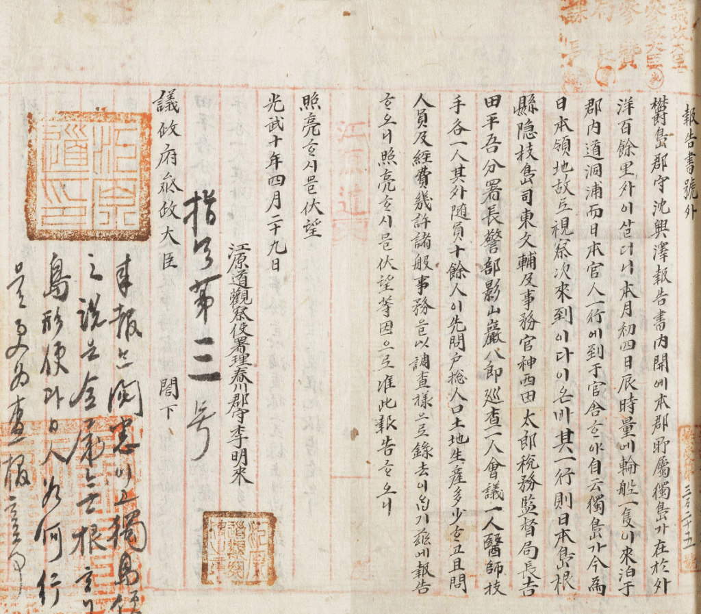
Thus, through Imperial Decree No. 41 issued by the Korean Empire in 1900, Dokdo was being administered as part of Ulleung County. However, on March 28, 1906, when a Japanese survey team from Shimane Prefecture visited Ulleungdo and made the unilateral claim that Japan had incorporated Dokdo into its territory. Sim Heung-taek, the county magistrate of Ulleung County, submitted a report the very next day—March 29—to the official of Gangwon Province, explicitly referring to Dokdo under the jurisdiction of Ulleung County and reporting Japan’s illegal seizure of the land. After receiving Sim’s report, Yi Myeong-rae, the acting governor of Gangwon Province and then the county magistrate of Chuncheon, forwarded the matter on April 29, 1906 to the Uijeongbu (State Council), the highest administrative body of the Korean Empire (Daehan Jeguk) at the time.
[translation]
Special Report
Report by Sim Heung-taek, Governor of Ulleung County
As stated in the contents of this report, the island of Dokdo, which belongs to this county, lies over one hundred ri offshore from the mainland. On the morning of the 4th of this month, a Japanese ship anchored at Dodong Port within the county, and a group of Japanese officials came to the county office. They claimed that Dokdo is now Japanese territory and that they were here to inspect it.
The group consisted of the following members: Higashi Bunpu, Governor of Oki Island, Shimane Prefecture; administrative official Kamizai Yutaro; Director of the Tax Supervision Bureau Yoshida Heigo; Branch Chief and Police Inspector Kageyama Ganpachiro; one police officer; one assembly member; and one doctor and one technician, along with more than ten attendants.
They first inquired about the total number of households and population, land area, and production. They also asked about personnel and expenses, and recorded various administrative matters as part of their investigation.
I respectfully submit this report and ask for your consideration and direction.
April 29, 1906
Sim Heung-taek, Governor of Ulleung County
Lee Myeong-rae, Acting Governor of Gangwon Province and Governor of Chuncheon County
To: His Excellency, Minister of State Affairs, Uijeongbu
[original text]
報告書 號外
鬱島郡守 沈興澤 報告書 內開에 本郡所屬 獨島가 在於本部外洋百餘里外이삽더니 本月初四日辰時量에 輪船一雙이 來泊于郡內道洞浦而 日本官人一行이 到于官舍ᄒᆞ야 自云獨島가 今爲日本領地故로 視察次來到이다 이온바 其一行則 日本島根縣隱岐島司東文輔及 事務官神西由太郞 稅務監督局長吉田平吾 分署長警部 影山巖八郞 巡査一人 會議員一人 醫師技手各一人 其外隨員十餘人이 先問戶摠人口土地生産多少ᄒᆞ고 且問人員及經費幾許 諸般事務를 以調査樣으로 錄去이ᄋᆞᆸ기 玆에 報告ᄒᆞ오니 照亮ᄒᆞ시믈 伏望等因으로 准此報告ᄒᆞ오니 照亮ᄒᆞ시믈 伏望.
光武十年 四月二十九日
江原道觀察使署理春川郡守 李明來
議政府參政大臣 閣下
Report by Sim Heung-taek, Governor of Ulleung County, and Acting Governor of Gangwon Province, Lee Myeong-rae
After receiving this report, Park Je-sun, Vice Minister of the Uijeongbu (State Council), did not acknowledge or accept Japan’s claim. On May 10, 2906, he issued an order stating that the claim that Dokdo belongs to Japan is groundless, and instructed officials to investigate the matter again and report back.
[translation]
Directive No. 3
The report has been reviewed and acknowledged. The claim that Dokdo is Japanese territory is completely baseless. Further investigation will be conducted regarding the island’s shape, location, and the actions of the Japanese.
May 10
[original text]
指令 第三號
來報 閱悉이고 獨島領地之說은 全屬無根니 該島 形便과 日人 如何 行動을 更爲査報ᄒᆞㄹ 事
五月十日
Directive No. 3 from the Vice Minister of the Uijeongbu regarding the report from the Governor of Uldo County
* Due to input issues with old Korean script, some characters are being displayed as “□”.
and the directive from the Vice Minister of the Uijeongbu in response
*source: Kyujanggak Institute for Korean Studies, Seoul National University
At the time, although the Korean Empire (Daehan Jeguk) had been forcibly stripped of its diplomatic rights and other national powers by Japan through the Japan-Korea Treaty on November 17, 1905, and Japan’s Resident-General had taken control of Korea’s foreign and domestic affairs by February 1, 1906, Korea did not tolerate Japan’s illegal actions regarding its territory.
In other words, even before and after Japan’s claimed incorporation of Dokdo in 1905, Dokdo continued to be Korean territory.
Japan’s actions in 1905 were nothing more than a baseless claim, secretly announcing Dokdo as part of Shimane Prefecture during the Russo-Japanese War for military purposes, under the premise that it was ownerless land (Terra Nullius).
As in the third claim, the current Japanese government argues that it established sovereignty over Dokdo in the mid-17th century. If Japan’s claim was true, it means that Japan incorporated into its territory in 1905 an island it had already supposedly held sovereignty over since the 17th century. If this were the case, Japan should have also taken similar incorporation or reaffirmation steps for its other territories.
However, there are no such cases—not in Japan, not even internationally—where a country has “reaffirmed sovereignty” over its own territory. The Japanese government first claimed in 1905 that Dokdo was “ownerless land”, but now it claims it had established sovereignty back in the 17th century. These are contradictory arguments, and to resolve this contradiction, Japan now puts forward yet another strange logic—that it “reaffirmed its sovereignty” in 1905.
We would like to ask Japan.
– Japan claims to have established sovereignty over Dokdo in the mid-17th century. If so, why did it attempt to secretly and unlawfully incorporate Dokdo in 1905, during the Russo-Japanese War, by declaring it “ownerless land”, rather than acknowledging it as territory it had already claimed?
– Are there any examples where Japan has reaffirmed its sovereignty over other islands or territories that it considers inherently Japanese? If not, does it have any such plans?
– Have you ever seen another country reaffirm its sovereignty over its own territory in a similar way, in international practice?
Japan’s Claim 7: In the process of drafting the San Francisco Peace Treaty, the Republic of Korea requested that the United States add Dokdo to the territories to be renounced by Japan. However, the United States rejected that request.
Japan claims that during the drafting of the 1951 San Francisco Peace Treaty, Korea requested that Dokdo be included among the territories Japan should renounce, but the United States rejected this request through a document by Dean Rusk, U.S. Assistant Secretary of State for Far Eastern Affairs. Based on this, Japan argues that Dokdo was recognized as Japanese territory in the treaty signed on September 8, 1951.
▶ TRUTH: The so-called “Rusk Document” represented only the temporary position of the United States at the time, not the official stance of the Allied Powers as a whole. Therefore, it holds no legal authority over the sovereignty of Dokdo. In fact, the San Francisco Peace Treaty indirectly reaffirmed Dokdo as Korean territory!
The Republic of Korea was established on August 15, 1948, and by the time the San Francisco Peace Treaty was signed on September 8, 1951, Dokdo was already part of the livelihood for Ulleungdo residents and under Korean sovereignty.
The treaty itself contains no clause excluding Dokdo from Korean territory, and there has been no treaty or international decision since then that denies Korean sovereignty over Dokdo.
If we look at the post-World War II settlement process, it clearly shows that Japan’s claim is unjustified.
On July 26, 1945, the leaders of the United States, the United Kingdom and China gathered in Potsdam, Germany, and issued the Potsdam Declaration, demanding Japan’s surrender. In this declaration, it was stated that Japan’s sovereignty would be limited to the islands of Honshu (本州), Hokkaido (北海道), Kyushu (九州) and Shikoku (四國), along with certain minor islands to be determined by the Allied Powers. Dokdo has never been included among the islands designated for Japan by the Allied Powers under this declaration—not even once to this day.
[original text]
(8) The terms of the Cairo Declaration shall be carried out and Japanese sovereignty shall be limited to the islands of Honshu, Hokkaido, Kyushu, Shikoku, and such minor island as we (Allied Powers) determine.
Potsdam Declaration
The official name is Proclamation Defining Terms for Japanese Surrender
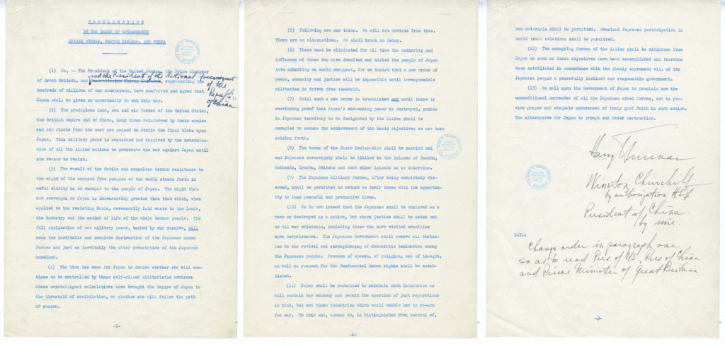
(excerpt above included in the center image)
*source: National Archives Catalog, U.S. National Archives and Records Administration
And on September 2, 1945, Japan signed the Instrument of Surrender, pledging to faithfully carry out the Potsdam Declaration, which stated that Japanese sovereignty would be limited to Honshu (本州), Hokkaido (北海道), Kyushu (九州) and Shikoku (四國), along with other minor islands as determined by the Allied Powers.
[original text]
We (Japan), …hereby accept the provisions set forth in the declaration issued by the heads of the Government of the United States, China, and the Great Britain on 26, July, 1945 at Potsdam, … We hereby undertake for the Emperor, Japanese Government and their successors to carry out the provisions of the Potsdam Declaration in good faith.
Instrument of Surrender
Japan’s surrender document to the Allied Powers
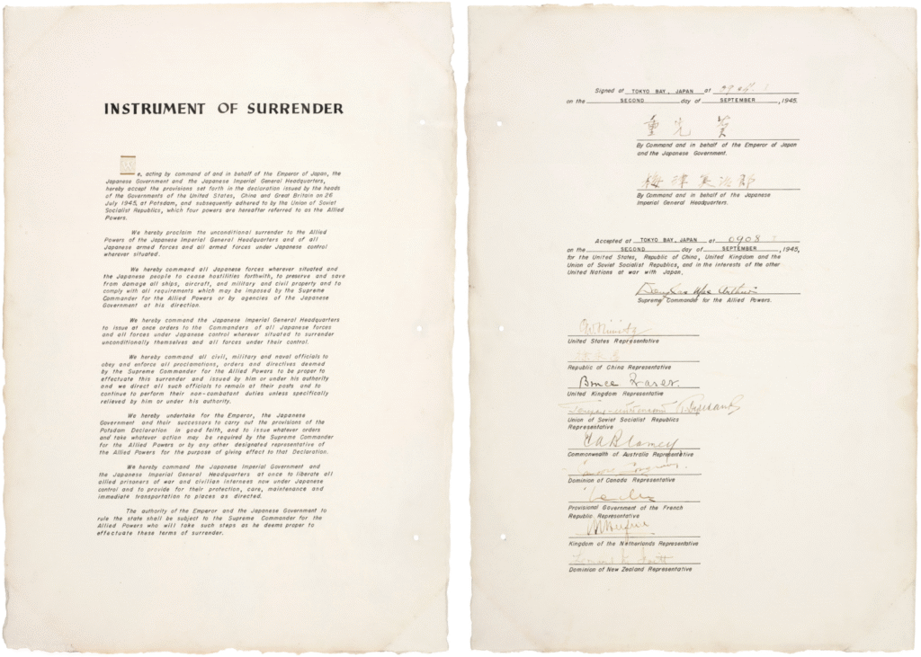
*source: National Archives Catalog, U.S. National Archives and Records Administration
From September 2, 1945, to April 28, 1952, when the San Francisco Peace Treaty came into effect, the Supreme Commander for the Allied Powers, which governed and occupied Japan, excluded Dokdo from Japan’s territory on January 29, 1946.
[original text]
3. For the purpose of this directive, Japan is defined to include the four main islands of Japan (Hokkaido, Honshu, Kyushu and Shikoku) and the approximately 1,000 smaller adjacent islands, including the Tsushima Islands and the Ryukyu (Nansei) Islands north of 30° North Latitude (excluding Kuchinoshima Island); and excluding (a) Utsuryo (Ullung) Island, Liancourt Rocks (Take Island *Dokdo) and Quelpart (Saishu or Cheju) Island, (b) the Ryukyu (Nansei) Islands south of 30° North Latitude (including Kuchinoshima Island), the Izu, Nanpo, Bonin (Ogasawara) and Volcano (Kazan or Iwo) Island Groups, and all the other outlying Pacific Islands [including the Daito (Ohigashi or Oagari) Island Group, and Parece Vela (Okino-tori), Marcus (Minami-tori) and Ganges (Nakano-tori) Islands], and (c) the Kurile (Chishima) Islands, the Habomai (Hapomaze) Island Group (including Suisho, Yuri, Akiyuri, Shibotsu and Taraku Islands) and Shikotan Island.
Supreme Commander for the Allied Powers Index No. 677
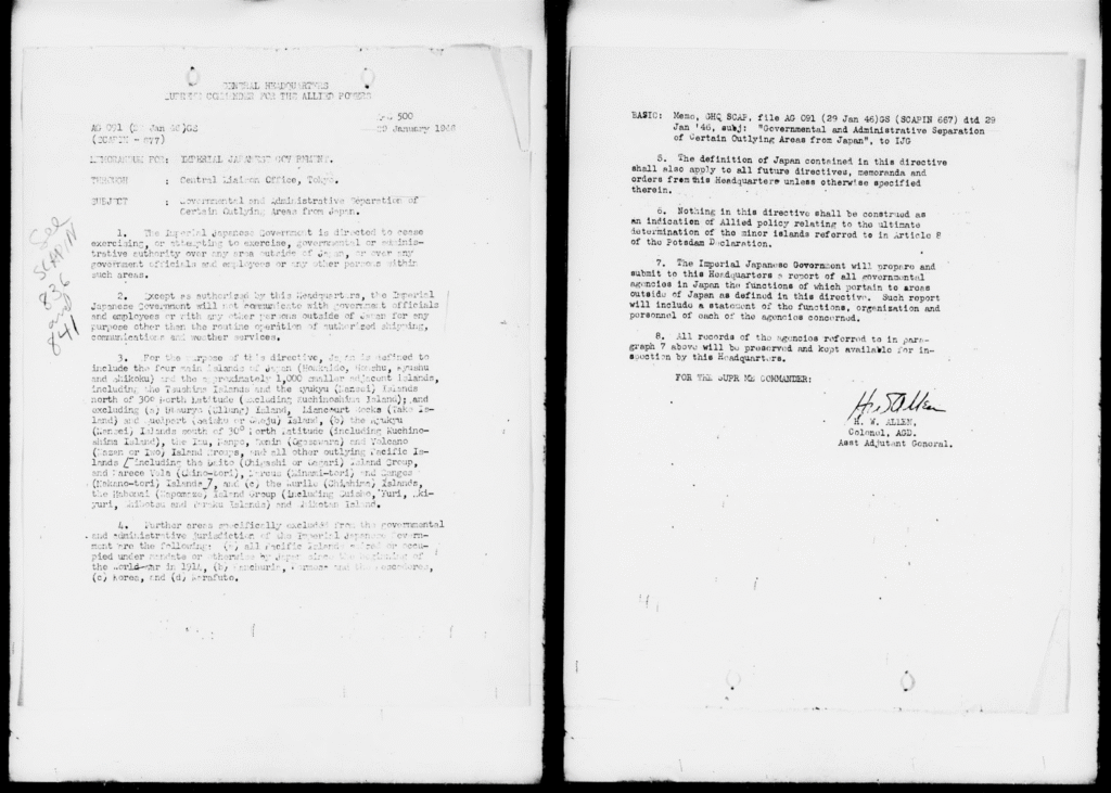
*source: NDL Digital Collections
The Supreme Commander for the Allied Powers, which had excluded Dokdo from Japanese territory, subsequently issued another order on June 22, 1946, prohibiting Japanese vessels and nationals from approaching Dokdo or entering within 12 nautical miles of the island.
[original text]
3. (b) Japanese vessels or personnel thereof will not approach closer than twelve (12) miles to Takeshima (*Dokdo) (37°15′ North Latitude, 131°53′ East Longitude) nor have any contact with said island.
Supreme Commander for the Allied Powers Index No. 1033
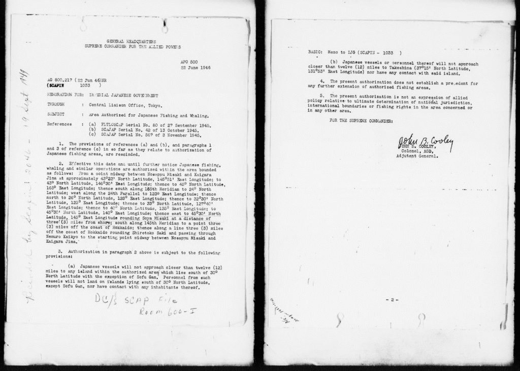
*source: NDL Digital Collections
The Treaty of Peace with Japan, signed on September 2, 1951, in San Francisco between Japan and the Allied Powers to address the settlement of issues following Japan’s initiation of the Pacific War, clearly states that Japan would recognize Korea’s independence and renounce all rights, titles, and claims to Korea. It also affirms the validity of all actions taken by the occupying authority (the Supreme Commander for the Allied Powers). Japan also signed the treaty. Nowhere in the treaty is Dokdo—Korean territory—designated as part of Japanese territory.
[original text]
Article 2
(a) Japan recognizing the independence of Korea, renounces all right, title and claim to Korea, including the islands of Quelpart, Port Hamilton and Dagelet.
Article 19
(d) Japan recognizes the validity of all acts and omissions done during the period of occupation under or in consequence of directives of the occupation authorities or authorized by Japanese law at that time, and will take no action subjecting Allied nationals to civil or criminal liability arising out of such acts or omissions.
San Francisco Peace Treaty (Treaty of Peace with Japan)
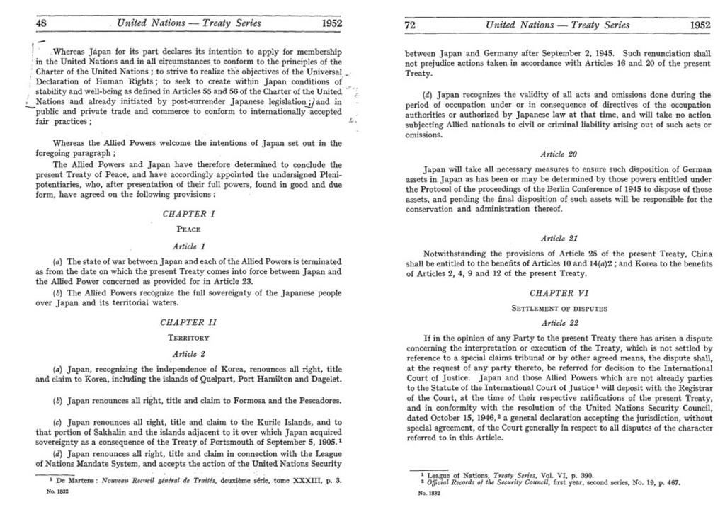
*source: United Nations Treaty Collection
The Allied Powers’ Supreme Commander, which was the occupying authority over Japan, excluded Dokdo from Japan’s territory (SCAPIN-677, January 29, 1946), and Japan signed the San Francisco Peace Treaty on September 2, 1951, agreeing to recognize the validity of the occupying authority’s actions. Therefore, far from recognizing Dokdo as Japanese territory, the San Francisco Peace Treaty confirmed the exclusion of Dokdo from Japan’s territory by the Allied Powers. Japan’s claim is therefore incorrect.
The Supreme Commander for the Allied Powers, which had excluded Dokdo from Japan’s territory through Memorandum No. 677 on January 29, 1946, adjusted the scope of Japan’s territory through Memorandum No. 677/1 on December 5, 1951, after the San Francisco Peace Treaty was signed on September 2, 1951. There were no changes regarding Dokdo, which had been excluded from Japan’s territory.
[original text]
1. Reference:
– a. Memorandum for the Japanese Government, AG 091(29 Jan 46)GS(SCAPIN 677), 29 January 1946, subject, “Governmental and Administraive Separation of Certain Outlying Areas from Japan”.
– b. Memorandum for the Japanese Government, AG 091(26 Mar 46)GS(SCAPIN 841), 26 March 1946, subject, “Governmental and Administraive Separation of Certain Outlying Areas from Japan”.
2. Paragraph 3 of reference a, as amended by reference b, is further amended so that the Ryukyu (Nansei) Islands north of 29° north latitude are included within the area defined as Japan for the purpose of that directive.
3. The Japanese Government is directed to resume governmental and administrative jurisdiction over these islands, subject to the authority of the Supreme Commander for the Allied Powers.
Supreme Commander for the Allied Powers Index No. 677/1
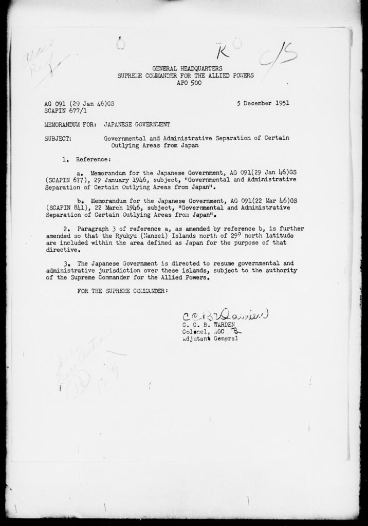
*source: NDL Digital Collections
As we can see from the post-World War II settlement process, the decisions made by the Allied Powers—including the Supreme Commander for the Allied Powers—excluded Dokdo from Japanese territory. Furthermore, the 1951 San Francisco Peace Treaty clearly stated that Japan must recognize Korea’s independence and renounce all rights, claims, and titles over Korea, and also acknowledge the validity of all actions taken by the Allied occupation authorities. Japan agreed to this by signing the treaty.
Therefore, interpreting the United States’ temporary stance as the official position of all the Allied Powers, or claiming that Dokdo—an inherent part of Korea’s territory over which Korea had continuously exercised territorial sovereignty even before the 1951 San Francisco Peace Treaty—was suddenly recognized as Japanese territory, is incorrect.
Japan’s Claim 8: Dokdo was designated as a bombing range for the U.S. Forces in Japan
Japan claims that Dokdo was recognized as its territory based on the fact that, in July 1952, it designated Dokdo as a bombing range for U.S. forces stationed in Japan through an administrative agreement with the United States, and that this designation was made in consultation with the U.S. government.
▶ TRUTH: At the time, the designation of the bombing range was made without Korea’s knowledge. Due to strong protests from the Korean government, Dokdo was immediately removed from the bombing range!
The U.S. Forces in Japan conducted bombing drills on Dokdo twice, and both times they were halted due to protests from the Korean government.
The first bombing occurred on June 8, 1948, during the U.S. military administration of Korea, prior to the establishment of the Republic of Korea. At the time, 59 Korean fishermen from Gangwon-do and Gyeongsangbuk-do, unaware of the drill, were fishing near Dokdo. The incident resulted in a tragic disaster: 14 people lost their lives, at least 6 others were seriously injured, and 14 boats were either sunk or damaged.
Immediately after the incident, the U.S. 24th Army Corps Command in Korea dispatched a special investigation team to conduct rescue operations and examine the case. Compensation was provided to the victims and their families. The U.S. military government in Seoul requested the Far East Command in Tokyo to halt all bombing exercises on Dokdo, which subsequently led to the suspension of the drills.
However, during the Korean War in 1952, Japan maneuvered to have Dokdo designated once again as a bombing range for U.S. Forces in Japan. Despite knowing that Korean fishermen operating in the area would likely suffer significant harm, Japan deliberately pushed for this designation as a means to assert its territorial claim over Dokdo. As a result, additional bombing exercises took place on September 15 and 22, causing further damage.
This series of events highlights Japan’s intentional efforts to reinforce its claim over Dokdo, even at the cost of Korean civilian lives and livelihoods.
[translation]
“Takeshima (Dokdo), located south of Ulleungdo, is extremely important for fishing… If it is not recognized as Japanese territory, then I hope we can find some way—any way—to make it ours.”
[original text]
울릉도 남쪽에 있는 竹島(독도)는 어업면에서 대단히 중요한데… 이것이 일본 영토가 아니라고 한다면 어떤 방법을 세워서라도 우리 것이면 하는 바람입니다.
Foreign Affairs Committee Meeting, House of Councilors of Japan, February 15, 1952
excerpt from KBS documentary broadcast on February 28, 2014:
“Dokdo Bombing, Japan Was Behind It”
[translation]
Yamamoto [Councilor]:
“Takeshima (Dokdo) has had a close relationship with Japan since the early Edo period, and it was declared Japanese territory in February of 1905, which was before the annexation of Korea. Therefore, there is absolutely no doubt that this is our country’s territory.
However, in setting up training grounds for the occupation forces stationed in Japan, if the area around Takeshima is designated as a training site, it may make it easier for our territorial rights to be recognized as belonging to Japan.
With this in mind, is it the case that the Ministry of Foreign Affairs is actually hoping for Takeshima to be designated as a training ground? I would like to ask your view on this.”
Ishihara [Government Official]:
“This is a matter I touched on briefly earlier, but yes, things seem to be proceeding more or less with that line of thinking.”
[original text]
○山本(利)委員: 竹島は江戸時代の初期から日本と密接な関係があつたものであり、さらに日本領土として宣言されたのは明治三十八年の二月のことでありますから、日韓併合より以前のことであつて、もうこれがわが国の領土であるということは、いささかの疑いもないところであります。ところが今度日本に駐留軍の演習地の設定にあたつて、その竹島あたりが演習地に指定されるならば、この領土権を日本のものと確認されやすい、そういうような考えから、これが演習地の指定を外務省がむしろ望んでおられるというようなことがあるかどうか、その点についてお伺いいたします。
○石原(幹)政府委員: これは先ほどちよつと触れた問題でありますが、大体そういう考え方でいろいろ進んでおるようであります。
Speakers No. 93 and No. 94 from the May 23, 1952 meeting of the 26th session of the Foreign Affairs Committee of the House of Representatives during Japan’s 13th National Diet
*source: Minutes of the Diet Database System, National Diet Library
In this context, when U.S. Forces stationed in Japan (USFJ) once again conducted bombing drills on Dokdo on September 15 and 22, 1952, it was witnessed by many Korean citizens — including fishermen and female divers (haenyeo) on Ulleungdo and Dokdo, as well as the Ulleungdo-Dokdo Academic Research Team of the Chosun Alpine Association. These witnesses immediately reported the situation to the Korean Navy and other government authorities.
In response to this, the Korean government lodged a formal protest, leading to the removal of Dokdo from the bombing training zones by USFJ in December 1952. The U.S. Embassy in Korea also officially notified the Korean government that Dokdo would no longer be used as a bombing range. In February 1953, the Korean Ministry of National Defense, after consultations with United Nations Command authorities, announced that there would be no further bombing on Dokdo. At the same time, the Commander of the U.S. Far East Air Forces also sent a letter to the Korean Minister of National Defense, reaffirming this commitment.
Importantly, the United States conveyed this decision only to the Korean government, not to the Japanese government. Japan only learned of these developments later through media reports.
This clearly contradicts Japan’s claim that the United States consulted with Japan and recognized Dokdo as Japanese territory. In reality, the United States, in response to Korea’s protest, excluded Dokdo from its bombing training grounds without involving Japan, thereby handling the issue in alignment with Korea’s position and excluding Japan from the decision-making process.
[translation]
○ Committee Member Kawakami: The Foreign Ministry says they excluded it because it is Japanese territory, but actually, they excluded it because there was a protest from Korea. It’s well known that Korea protested. When Korea protested, they excluded it. So, what you’re saying is backwards — the interpretation is that America sided with Korea and therefore excluded it.
[original text]
○川上委員: 外務当局は日本の領土だから除くと言つているのですが、韓国から抗議があつたから
除いておるのです。韓国から抗議があつたことはわかり切つたことなんです。韓国から抗議があつた、そうしたらそれを除いた、こういうことになつておる。だからあなたの言うのはさかさであつて、アメリカは韓国側だと思つておるから除いた、こういう解釈が成り立つわけです。
Speaker No. 150 from the November 4, 1953 meeting of the 5th session of the Foreign Affairs Committee of the House of Representatives during Japan’s 17th National Diet
*source: Minutes of the Diet Database System, National Diet Library
Therefore, it is not reasonable to claim Dokdo as Japanese territory based on the fact that it was designated as a bombing training site for the U.S. Forces Japan due to Japan’s malicious intent.
The bombing training was stopped and Dokdo was excluded from the training area at Korea’s request, and the fact that the U.S. only notified the Korean government of this indicates that the U.S. did not recognize Dokdo as Japanese territory.
Japan’s Claim 9: The Republic of Korea delineated the so-called “Syngman Rhee Line” on the high seas in contravention of international law, and illegally occupied Dokdo as a unilateral act
Japan claims that Korea’s “Proclamation of Sovereignty over Adjacent Seas” on January 18, 1952 (commonly known as the Syngman Rhee Line) violates international law and that by including Dokdo within this line, Korea is illegally occupying Dokdo in a unilateral manner.
▶ TRUTH: The “Proclamation of Sovereignty Over Adjacent Seas” was a legitimate measure by Korea to protect its maritime territory, and Dokdo had already been under Korean sovereignty long before this proclamation!
As early as June 22, 1946, the Supreme Commander for the Allied Powers, which was administering Japan after World War II, issued SCAPIN-1033, known as the MacArthur Line. It prohibited Japanese vessels and nationals from approaching within 12 nautical miles of Dokdo. Despite these restrictions, more than 40 cases of violations were detected in 1951 alone, and a Korean patrol ship was nearly sunk by attacks from Japanese fishing boats. These illegal incursions were causing significant damage to Korea.
Therefore, the “Proclamation of Sovereignty Over Adjacent Seas” was a reasonable and lawful action by a sovereign state to protect its maritime zone and its fishermen during a time of heightened tension and frequent violations.
On September 25, 1952, the Ministry of Foreign Affairs of the Republic of Korea issued a statement titled “한국 인접해안에 대한 보호수역 선포의 근거”(韓國 隣接海岸에 対한 保護水域 宣布의 根據), formally explaining the grounds and necessity of the January 18, 1952 proclamation.
On April 13, 1956, during a session of the Judicial Affairs Committee of the House of Representatives of Japan, then Minister of State Mamoru Shigemitsu (重光葵) responded to a question regarding Korea’s actions, including the Syngman Rhee Line. In his reply, Shigemitsu effectively acknowledged the validity of the Peace Line, recognizing its practical effect at the time.
[translation]
○Minister of State Shigemitsu: Since the San Francisco Peace Treaty, Korea has been an independent nation. While there may be various international opinions and criticisms about how it exercises its sovereignty, I believe that is acceptable. However, Japan cannot deny that sovereignty.
[original text]
○重光国務大臣: サンフランシスコ平和条約以来韓国は独立国となっておる。それが独立国の主権を運用して、その運用の仕方の批評は国際的にいろいろあって差しつかえはないものとも思いますが、そのことについて日本がこれを否認していくということはできぬことであります。
Speaker No. 18 in the minutes of the 24th Session of Japan’s 24th National Diet, House of Representatives Legal Affairs Committee, Meeting No. 24 (24th National Diet, House of Representatives Legal Affairs Committee, No. 24, April 13, 1956)
*source: Minutes of the Diet Database System, National Diet Library
Separate from the Syngman Rhee Line, which was a measure for the protection of Korea’s waters and fishermen, Dokdo has been an integral part of Korean territory since ancient times, as it is an adjunct island of Ulleungdo, historically part of the residential and economic zone of the Ulleungdo residents.
On August 20, 1947, during the U.S. military occupation and transitional government period, the Ulleungdo Scientific Research Team visited Dokdo. They investigated the geology, ocean currents, and fishing conditions of the island, while also collecting plant and animal specimens. As mentioned in claim 8, on June 8, 1948, a tragic accident occurred when 14 Korean fishermen were killed during a bombing training by the U.S. military. This further confirmed Dokdo was still within the active zone for Korean people at the time.
In particular, after the establishment of the Republic of Korea on August 15, 1948,
the Korean government officially designated the address of the island as “1 Do-dong, Nam-myeon, Ulleung-gun, Gyeongsangbuk-do”, exercising sovereignty over it. Notably, the Japanese government raised no objections to this action.
Therefore, the declaration of the Syngman Rhee Line by the Korean government on January 18, 1952, was a legitimate action to protect Korea’s waters and fishermen, and Dokdo was not an island illegally occupied by Korea but an area of Korean sovereignty, historically utilized by the Ulleungdo residents and other Korean people for their livelihoods.
Japan’s Claim 10: Japan has been repeatedly proposing to the Republic of Korea that the dispute over the sovereignty of Dokdo should be referred to the International Court of Justice (ICJ). However, the Republic of Korea is refusing these proposals.
Japan claims that it proposed to refer to the Dokdo matter to the International Court of Justice (ICJ) for peaceful settlement under international law in September 1954, March 1962, and August 2012, but that Korea refused each time.
▶ TRUTH: Dokdo is not a matter of dispute but clearly Korean territory—there is no reason to take it to the ICJ!
Dokdo is clearly Korean territory based on history, geography, and international law, and the Republic of Korea is currently exercising full territorial sovereignty over it. Therefore, Dokdo is not subject to diplomatic negotiation or judicial resolution, and this is the official stance of the Korean government.
In response to the Ministry of Foreign Affairs of Japan note dated September 25, 1954, which included the proposal to refer to the matter of Dokdo’s sovereignty to the ICJ, the Korean government delivered its official position through a diplomatic note on October 28, 1954, stating the following:
[translation]
Memorandum of the Korean Mission (excerpt)
2. The Japanese government’s proposal to bring the dispute before the International Court of Justice is nothing more than another attempt to falsely claim sovereignty under the guise of legal proceedings. Korea has held territorial rights over Dokdo from the very beginning, and does not recognize any reason to seek confirmation of its rights at the International Court of Justice. It is Japan that is fabricating a pseudo territorial dispute where no dispute exists.
[original text]
대표부 각서 (중략)
2. 분쟁을 국제사법재판소에 부탁하자는 일본 정부의 제안은 사법적인 가장으로써 허위 주장하는 또 하나의 기도에 불과하다. 한국은 독도에 대하여 시초부터 영토권을 가지고 있으며 그의 권리에 대한 확인을 국제사법재판소에서 구하여야 한다는 이유를 인정하지 않는다. 아무런 분쟁도 있을 수 없는데도 유사적 영토 분쟁을 조작하는 것은 바로 일본이다.
October 28, 1954
Memorandum of the Republic of Korea Mission in Japan
(Quoted in Introduction to the Dokdo Issue, compiled by the Bureau of Political Affairs, Ministry of Foreign Affairs, May 1955)
*source: Digital Library, National Assembly Library
(Quoted in Introduction to the Dokdo Issue, compiled by the Bureau of Political Affairs,
Ministry of Foreign Affairs, May 1955)
*source: Digital Library, National Assembly Library
Dokdo is not a disputed territory that requires judicial or diplomatic resolution—it is clearly Korean territory. The real issue that needs to be addressed is Japan’s one-sided, false claims.
We urge Japan to acknowledge the historical truth, reflect on this imperialistic past, and stop making unjust claims and taking actions that hurt Korea, including those related to Dokdo and other historical and territorial matters. As a neighboring country, we hope Japan will become a more trustworthy nation.